
Faça uma doação
Mapa topográfico Tel Aviv District
Clique no mapa para exibir a altitude.
Faça uma doação
Sobre este mapa
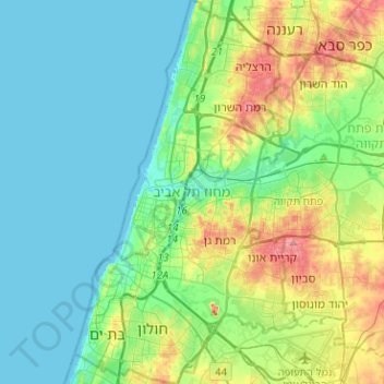
Nome: Mapa topográfico Tel Aviv District, altitude, relevo.
Local: Tel Aviv District, Israel (31.98872 34.72875 32.20292 34.87574)
Altitude média: 24 m
Altitude mínima: -1 m
Altitude máxima: 91 m
Faça uma doação
Outros mapas topográficos
Clique em um mapa para visualizar sua topografia, sua altitude e seu relevo.
Haifa
Haifa is the center of liberal Arabic-speaking culture, as it was under British colonial rule. The Arabic-speaking neighborhoods, which are mixed Muslim and Christian, are in the lowlands near the sea, while Jewish neighborhoods are at higher elevation. An active Arab cultural life has developed in the 21st…
Altitude média: 100 m
Jerusalem
Jerusalem is situated on the southern spur of a plateau in the Judaean Mountains, which include the Mount of Olives (East) and Mount Scopus (North East). The elevation of the Old City is approximately 760 m (2,490 ft). The whole of Jerusalem is surrounded by valleys and dry riverbeds (wadis). The Kidron,…
Altitude média: 520 m
Golan Heights
Israel > North District > Golan Regional Council
The plateau that Israel controls is part of a larger area of volcanic basalt fields stretching north and east that were created in the series of volcanic eruptions that began recently in geological terms, almost 4 million years ago. The rock forming the mountainous area in the northern Golan Heights,…
Altitude média: 533 m
Faça uma doação
Golan Heights
The plateau that Israel controls is part of a larger area of volcanic basalt fields stretching north and east that were created in a series of volcanic eruptions that began recently in geological terms, almost 4 million years ago. The rock forming the mountainous area in the northern Golan Heights, descending…
Altitude média: 406 m
Faça uma doação
Faça uma doação
Kiryat Shmona
Kiryat Shmona is located in the Finger of the Galilee next to Hula Valley, about 5 kilometres (3 miles) south and 2 km (1 mile) east of the Israel–Lebanon border. Its elevation is about 150 metres (492 feet) above sea level.
Altitude média: 236 m
Modiin-Maccabim-Reut
הנחלים HaNechalim – The Rivers (Safdie) and משואה Masuah – Beacon (Givat C) are located towards the west of the city, and were planned by architect Moshe Safdie. Located in these neighborhoods are five commercial centers, a secondary school and three primary schools. The central street names are…
Altitude média: 240 m
Faça uma doação
Faça uma doação
Faça uma doação
Faça uma doação
Mount Meron
Israel > North District > Merom HaGalil Regional Council
In 1965, an 84,000-dunam nature reserve was declared. An additional 1,199 dunams were declared part of the reserve in 2005. It is the highest reserve in Israel, at an altitude of 1,204 meters above sea level, and the largest reserve in the north of the country.
Altitude média: 943 m
Har Bental
Israel > North District > Golan Regional Council
Mount Bental (Arabic: جبل بنطل, جبل الغرام / ALA-LC: Jabal al-Gharam / "Mountain of Lust" "Jabal Bental"; Hebrew: הר בנטל, Har Bental, "Mount Bental" (lit. "Son of Dew") is a dormant volcano in the North-Eastern part of the Golan Heights, It extends to an elevation of 1,171 meters above sea level.
Altitude média: 975 m
Faça uma doação
Faça uma doação
Faça uma doação
Caesarea National Park
Israel > Haifa District > Hof HaCarmel Regional Council > Caesarea
Altitude média: 8 m
Faça uma doação
Faça uma doação
2236 Mt. Hermon
Israel > North District > Golan Regional Council
Mount Hermon (Arabic: جبل الشيخ / ALA-LC: Jabal al-Shaykh ('Mountain of the Sheikh', Levantine Arabic pronunciation: [ʒa.bal eʃ.ʃeːx]), Hebrew: הַר חֶרְמוֹן, Har Ḥermōn) is a mountain cluster constituting the southern end of the Anti-Lebanon mountain range. Its summit straddles the…
Altitude média: 2.016 m
Faça uma doação
Golan Heights
The Golan Heights is a basaltic plateau in southwestern Syria, extending about 44 miles (71 km) from north to south and about 27 miles (43 km) from east to west at its widest point, covering approximately 444 square miles (1,150 square km). The terrain is characterized by its hilly and elevated nature, with an…
Altitude média: 406 m
Faça uma doação
Faça uma doação
Faça uma doação
Meron
Israel > North District > Merom HaGalil Regional Council
Meron is noted for its mountainous terrain and valleys. Among the local attractions are the Meron Vineyards. Meron is conducive to growing grapes for wine as a result of its 600-meter altitude and chalky soil. The vineyard was first planted in 2000 and is part of the Galil Mountain Winery, headquartered in…
Altitude média: 735 m
Kiryat Shmona
Kiryat Shmona is located in the Finger of the Galilee next to Hula Valley, about 5 kilometres (3 miles) south and 2 km (1 mile) east of the Israel–Lebanon border. Its elevation is about 150 metres (492 feet) above sea level.
Altitude média: 227 m
Faça uma doação
Faça uma doação
Faça uma doação
Mount Meron
Israel > North District > Merom HaGalil Regional Council
Mount Meron (Hebrew: הַר מֵירוֹן, Har Meron; Arabic: جبل الجرمق, Jabal al-Jarmaq) is a mountain in the Upper Galilee region of Israel. It has special significance in Jewish religious tradition and parts of it have been declared a nature reserve. At 1,204 metres (3,950 ft) above sea level,…
Altitude média: 943 m
Faça uma doação
Faça uma doação
Faça uma doação
Faça uma doação
El Rom
Israel > North District > Golan Regional Council
The kibbutz is about ten kilometers (6.2 mi) south of Mount Hermon, at an elevation of 1,050–1,070 meters (3,440–3,510 ft) above sea level. El Rom and the nearby moshav Odem are the two Jewish settlements in Israel with the highest elevation after Nimrod.
Altitude média: 1.062 m
Faça uma doação
Faça uma doação