
Faça uma doação
Mapa topográfico Mount Meron
Clique no mapa para exibir a altitude.
Faça uma doação
Mount Meron
In 1965, an 84,000-dunam nature reserve was declared. An additional 1,199 dunams were declared part of the reserve in 2005. It is the highest reserve in Israel, at an altitude of 1,204 meters above sea level, and the largest reserve in the north of the country.
Faça uma doação
Sobre este mapa
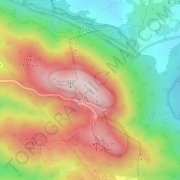
Nome: Mapa topográfico Mount Meron, altitude, relevo.
Altitude média: 943 m
Altitude mínima: 717 m
Altitude máxima: 1.194 m
Faça uma doação
Outros mapas topográficos
Clique em um mapa para visualizar sua topografia, sua altitude e seu relevo.
Meron
Israel > North District > Merom HaGalil Regional Council
Meron is noted for its mountainous terrain and valleys. Among the local attractions are the Meron Vineyards. Meron is conducive to growing grapes for wine as a result of its 600-meter altitude and chalky soil. The vineyard was first planted in 2000 and is part of the Galil Mountain Winery, headquartered in…
Altitude média: 735 m
Faça uma doação