
Faça uma doação
Mapa topográfico Tabriz
Clique no mapa para exibir a altitude.
Faça uma doação
Tabriz
Tabriz is in the Quru River valley in Iran's historic Azerbaijan region between long ridges of volcanic cones in the Sahand and Eynali mountains. Tabriz's elevation ranges between 1,350 and 1,600 m (4,430 and 5,250 ft) above sea level. The valley opens up into a plain that gently slopes down to the eastern shores of Lake Urmia, 60 km (37 mi) to the west. The city was named World Carpet Weaving City by the World Crafts Council in October 2015 and Exemplary Tourist City of 2018 by the Organisation of Islamic Cooperation.
Faça uma doação
Sobre este mapa
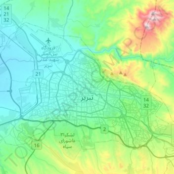
Nome: Mapa topográfico Tabriz, altitude, relevo.
Altitude média: 1.538 m
Altitude mínima: 1.327 m
Altitude máxima: 2.360 m
Faça uma doação
Outros mapas topográficos
Clique em um mapa para visualizar sua topografia, sua altitude e seu relevo.