
Faça uma doação
Mapa topográfico Iskandar
Clique no mapa para exibir a altitude.
Faça uma doação
Sobre este mapa
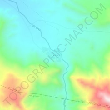
Nome: Mapa topográfico Iskandar, altitude, relevo.
Altitude média: 1.806 m
Altitude mínima: 1.622 m
Altitude máxima: 2.278 m
Faça uma doação
Outros mapas topográficos
Clique em um mapa para visualizar sua topografia, sua altitude e seu relevo.
Tabriz
Iran > East Azerbaijan Province > Tabriz County
Tabriz (Persian: تبریز [tæbˈɾiːz] (listen); Azerbaijani: تبریز) is a city in northwestern Iran, serving as the capital of East Azerbaijan Province. It is the sixth-most-populous city in Iran. In the Quru River valley in Iran's historic Azerbaijan region between long ridges of volcanic cones in…
Altitude média: 1.538 m
Tabriz
Iran > East Azerbaijan Province > Tabriz County
Tabriz is in the Quru River valley in Iran's historic Azerbaijan region between long ridges of volcanic cones in the Sahand and Eynali mountains. Tabriz's elevation ranges between 1,350 and 1,600 m (4,430 and 5,250 ft) above sea level. The valley opens up into a plain that gently slopes down to the eastern…
Altitude média: 1.538 m
Faça uma doação
Tabriz
Iran > East Azerbaijan Province > Tabriz County
Tabriz is in the Quru River valley in Iran's historic Azerbaijan region between long ridges of volcanic cones in the Sahand and Eynali mountains. Tabriz's elevation ranges between 1,350 and 1,600 m (4,430 and 5,250 ft) above sea level. The valley opens up into a plain that gently slopes down to the eastern…
Altitude média: 1.538 m
دهستان میدان چای
Iran > East Azerbaijan Province > Tabriz County > دهستان میدان چای
Altitude média: 2.075 m