
Faça uma doação
Mapa topográfico Boston
Clique no mapa para exibir a altitude.
Faça uma doação
Sobre este mapa
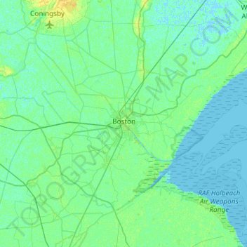
Nome: Mapa topográfico Boston, altitude, relevo.
Altitude média: 3 m
Altitude mínima: -2 m
Altitude máxima: 14 m
Faça uma doação
Outros mapas topográficos
Clique em um mapa para visualizar sua topografia, sua altitude e seu relevo.
Faça uma doação
Faça uma doação
The Lymn
United Kingdom > England > Lincolnshire > East Lindsey > Thorpe St. Peter
Altitude média: 2 m
Faça uma doação
Faça uma doação
Faça uma doação
Faça uma doação
Faça uma doação
Faça uma doação
Caen Hill
United Kingdom > England > Lincolnshire > West Lindsey > Great Limber CP
Altitude média: 83 m
Holbeach Clough
United Kingdom > England > Lincolnshire > South Holland > Holbeach CP > Saracen's Head
Altitude média: 4 m
Faça uma doação
Moor Barn
United Kingdom > England > Lincolnshire > South Kesteven > Hough-on-the-Hill
Altitude média: 31 m
Faça uma doação
Faça uma doação
Helpringham
United Kingdom > England > Lincolnshire > North Kesteven > Helpringham
Altitude média: 8 m
Faça uma doação
Old Somerby
United Kingdom > England > Lincolnshire > South Kesteven > Old Somerby
Altitude média: 115 m
Faça uma doação
Faça uma doação
Faça uma doação
Faça uma doação
Faça uma doação
Faça uma doação
Faça uma doação
Faça uma doação
Faça uma doação
Shepeau Stow
United Kingdom > England > Lincolnshire > South Holland > Whaplode Drove
Altitude média: 2 m
Faça uma doação
Faça uma doação
Low Fulney Estate
United Kingdom > England > Lincolnshire > South Holland > Spalding
Altitude média: 4 m
Faça uma doação
Sempringham
United Kingdom > England > Lincolnshire > South Kesteven > Pointon
Sempringham consists of a church and a holy well, with other houses east from the church scattered along the B1177 between Pointon and Billingborough. The church stands at an altitude of about 52 feet (16 m), on land rising out of flat fenland. Pointon is the chief township of the civil parish, which includes…
Altitude média: 16 m
Faça uma doação