
Faça uma doação
Mapa topográfico Cherry Willingham
Clique no mapa para exibir a altitude.
Faça uma doação
Sobre este mapa
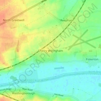
Nome: Mapa topográfico Cherry Willingham, altitude, relevo.
Altitude média: 16 m
Altitude mínima: -1 m
Altitude máxima: 39 m
Faça uma doação
Outros mapas topográficos
Clique em um mapa para visualizar sua topografia, sua altitude e seu relevo.
Welton CP
United Kingdom > England > Lincolnshire > West Lindsey
The parish stretches from the ancient Ermine Street (A15) in the west, following a north-easterly shape to the Barlings Eau at its eastern end, of which the Welton Beck is a tributary, and is an example of a strip parish. Due to the low, flat topography of Lincolnshire, land had to be drained for agriculture…
Altitude média: 27 m
Faça uma doação
Faça uma doação
Faça uma doação
Faça uma doação
Faça uma doação
Faça uma doação
Faça uma doação
Faça uma doação
Faça uma doação
Faça uma doação
North Willingham CP
United Kingdom > England > Lincolnshire > West Lindsey > North Willingham CP
Altitude média: 82 m
Faça uma doação
Corringham CP
United Kingdom > England > Lincolnshire > West Lindsey > Corringham CP
Altitude média: 21 m
Faça uma doação
Faça uma doação
Faça uma doação