
Mapa topográfico Mount Hood
Mapa interativo
Clique no mapa para exibir a altitude.
Sobre este mapa
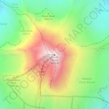
Nome: Mapa topográfico Mount Hood, altitude, relevo.
Local: Mount Hood, Hood River County, Oregon, United States (45.37346 -121.69593 45.37356 -121.69583)
Altitude média: 2.716 m
Altitude mínima: 2.213 m
Altitude máxima: 3.416 m
Timberline Lodge is a National Historic Landmark located on the southern flank of Mount Hood just below Palmer Glacier, with an elevation of about 6,000 ft (1,800 m).
Outros mapas topográficos
Clique em um mapa para visualizar sua topografia, sua altitude e seu relevo.
Hood River
United States > Oregon > Hood River County
Hood River, Hood River County, Oregon, United States
Altitude média: 112 m
Parkdale
United States > Oregon > Hood River County > Parkdale
Parkdale, Hood River County, Oregon, United States
Altitude média: 538 m
Odell
United States > Oregon > Hood River County
Odell, Hood River County, Oregon, United States
Altitude média: 244 m
Badger Lake Dam
United States > Oregon > Hood River County
Badger Lake Dam, Hood River County, Oregon, United States
Altitude média: 1.565 m
Government Cove
United States > Oregon > Hood River County > Cascade Locks
Government Cove, Cascade Locks, Hood River County, Oregon, United States
Altitude média: 89 m
Cascade Locks Marine Park
United States > Oregon > Hood River County > Cascade Locks
Cascade Locks Marine Park, Cascade Locks, Hood River County, Oregon, United States
Altitude média: 72 m
Dee
United States > Oregon > Hood River County
Dee, Hood River County, Oregon, United States
Altitude média: 424 m
Columbia River
United States > Oregon > Hood River County > Cascade Locks
Columbia River, Cascade Locks, Hood River County, Oregon, United States
Altitude média: 543 m
Cascade Locks
United States > Oregon > Hood River County
Cascade Locks, Hood River County, Oregon, United States
Altitude média: 101 m
Shellrock Spring
United States > Oregon > Hood River County
Shellrock Spring, Forest Road 17, Hood River County, Oregon, United States
Altitude média: 1.157 m