
Mapa topográfico Hood River
Mapa interativo
Clique no mapa para exibir a altitude.
Sobre este mapa
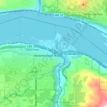
Nome: Mapa topográfico Hood River, altitude, relevo.
Local: Hood River, Hood River County, Oregon, United States (45.69298 -121.56508 45.72651 -121.49538)
Altitude média: 112 m
Altitude mínima: 14 m
Altitude máxima: 504 m
Temperatures for the year as a whole are slightly cooler than in most other low-elevation towns in the region, especially at night because of air drainage off the surrounding mountains.
Outros mapas topográficos
Clique em um mapa para visualizar sua topografia, sua altitude e seu relevo.
Odell
United States > Oregon > Hood River County
Odell, Hood River County, Oregon, United States
Altitude média: 244 m
Parkdale
United States > Oregon > Hood River County > Parkdale
Parkdale, Hood River County, Oregon, United States
Altitude média: 538 m
Badger Lake Dam
United States > Oregon > Hood River County
Badger Lake Dam, Hood River County, Oregon, United States
Altitude média: 1.565 m
Government Cove
United States > Oregon > Hood River County > Cascade Locks
Government Cove, Cascade Locks, Hood River County, Oregon, United States
Altitude média: 89 m
Cascade Locks Marine Park
United States > Oregon > Hood River County > Cascade Locks
Cascade Locks Marine Park, Cascade Locks, Hood River County, Oregon, United States
Altitude média: 72 m
Mount Hood
United States > Oregon > Hood River County
Mount Hood, Hood River County, Oregon, United States
Altitude média: 2.716 m
Dee
United States > Oregon > Hood River County
Dee, Hood River County, Oregon, United States
Altitude média: 424 m
Columbia River
United States > Oregon > Hood River County > Cascade Locks
Columbia River, Cascade Locks, Hood River County, Oregon, United States
Altitude média: 543 m
Cascade Locks
United States > Oregon > Hood River County
Cascade Locks, Hood River County, Oregon, United States
Altitude média: 101 m
Shellrock Spring
United States > Oregon > Hood River County
Shellrock Spring, Forest Road 17, Hood River County, Oregon, United States
Altitude média: 1.157 m