
Faça uma doação
Mapa topográfico Nunnington
Clique no mapa para exibir a altitude.
Faça uma doação
Sobre este mapa
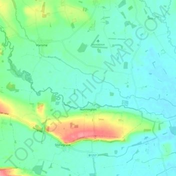
Nome: Mapa topográfico Nunnington, altitude, relevo.
Local: Nunnington, Ryedale, North Yorkshire, England, United Kingdom (54.18948 -1.00628 54.23693 -0.89359)
Altitude média: 42 m
Altitude mínima: 23 m
Altitude máxima: 103 m
Faça uma doação
Outros mapas topográficos
Clique em um mapa para visualizar sua topografia, sua altitude e seu relevo.
Farndale
United Kingdom > England > North Yorkshire > Ryedale > Gillamoor
With the population having decreased greatly from the 668 that is recorded in "A Topographical Dictionary of Yorkshire" by Thomas Lansdale published in 1822 when farndale East side had a population of 455 and Farndale West Side had a Population of 213.
Altitude média: 273 m
Willerby Brow Plantation
United Kingdom > England > North Yorkshire > Ryedale > Staxton > Binnington
Altitude média: 100 m
Faça uma doação