
Obrigado por apoiar este site ❤️
Faça uma doação
Faça uma doação
Mapa topográfico Farndale
Clique no mapa para exibir a altitude.
Obrigado por apoiar este site ❤️
Faça uma doação
Faça uma doação
Farndale
With the population having decreased greatly from the 668 that is recorded in "A Topographical Dictionary of Yorkshire" by Thomas Lansdale published in 1822 when farndale East side had a population of 455 and Farndale West Side had a Population of 213.
Obrigado por apoiar este site ❤️
Faça uma doação
Faça uma doação
Sobre este mapa
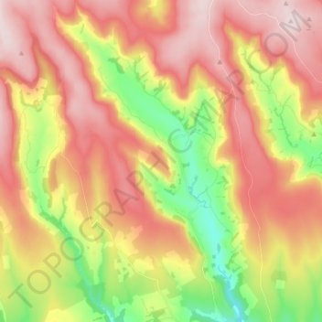
Nome: Mapa topográfico Farndale, altitude, relevo.
Altitude média: 273 m
Altitude mínima: 86 m
Altitude máxima: 431 m
Obrigado por apoiar este site ❤️
Faça uma doação
Faça uma doação