
Mapa topográfico Mauloff
Clique no mapa para exibir a altitude.
Sobre este mapa
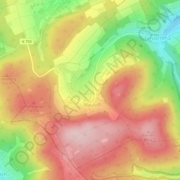
Nome: Mapa topográfico Mauloff, altitude, relevo.
Local: Mauloff, Weilrod, Hochtaunuskreis, Hesse, Germany (50.27433 8.37872 50.29779 8.41275)
Altitude média: 524 m
Altitude mínima: 377 m
Altitude máxima: 630 m
Outros mapas topográficos
Clique em um mapa para visualizar sua topografia, sua altitude e seu relevo.
Großer Feldberg
Germany > Hesse > Hochtaunuskreis > Schmitten im Taunus
The Großer Feldberg ('Great Field Mountain') is, at a height of 879.5 metres, the highest elevation of the Taunus mountains, and of the entire Rhenish Massif. It is situated in the Hochtaunuskreis district in Hesse, Germany.
Altitude média: 716 m
Saubach und Niedgesbach bei Schmitten
Germany > Hesse > Hochtaunuskreis > Finsternthal
Altitude média: 549 m