
Mapa topográfico Bonaire
Mapa interativo
Clique no mapa para exibir a altitude.
Sobre este mapa
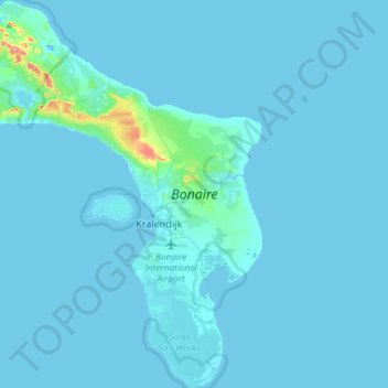
Nome: Mapa topográfico Bonaire, altitude, relevo.
Local: Bonaire, Netherlands (12.02473 -68.42095 12.31217 -68.19547)
Altitude média: 6 m
Altitude mínima: -2 m
Altitude máxima: 181 m
Klein Bonaire, the small island in the sheltered lee of Bonaire, has the same geological history. While Bonaire has some hills and variations in altitude, Klein Bonaire's surface is quite level and just a few feet above high tide. Because the island is as yet undeveloped, the fringing reef system surrounding Klein Bonaire is truly pristine. The smaller island is entirely ringed with dive sites.
Outros mapas topográficos
Clique em um mapa para visualizar sua topografia, sua altitude e seu relevo.
Oud-Loosdrecht
Netherlands > North Holland > Loosdrecht
Oud-Loosdrecht, Loosdrecht, Wijdemeren, North Holland, Netherlands, 1231 LV, Netherlands
Altitude média: -1 m
Boskoop
Boskoop, Alphen aan den Rijn, South Holland, Netherlands
Altitude média: -2 m
Eiland van Bèr
Netherlands > Limburg > Maastricht
Eiland van Bèr, Maastricht, Limburg, Netherlands, 6212 NE, Netherlands
Altitude média: 137 m
Gorinchem
Netherlands > South Holland > Gorinchem
Gorinchem, South Holland, Netherlands
Altitude média: 1 m
Spijkenisse
Spijkenisse, Nissewaard, South Holland, Netherlands
Altitude média: 1 m
Twente
Netherlands > Overijssel > Saasveld
Twente, Saasveld, Dinkelland, Overijssel, Netherlands, 7597 KL, Netherlands
Altitude média: 36 m
Zeewolde
Netherlands > Flevoland > Zeewolde
Zeewolde, Flevoland, Netherlands, Zeewolde
Altitude média: -2 m
Warmenhuizen
Warmenhuizen, Schagen, North Holland, Netherlands
Altitude média: 0 m
Badhoevedorp
Badhoevedorp, Haarlemmermeer, North Holland, Netherlands
Altitude média: -2 m
Zwarte Water
Netherlands > Overijssel > Zwolle
Zwarte Water, Binnenstad, Zwolle, Overijssel, Netherlands, 8031 ES, Netherlands
Altitude média: 4 m
Purmerend
Netherlands > North Holland > Purmerend
Purmerend, North Holland, Netherlands
Altitude média: -2 m
's-Hertogenbosch
Netherlands > North Brabant > 's-Hertogenbosch
's-Hertogenbosch, North Brabant, Netherlands
Altitude média: 4 m
Amsterdam
Netherlands > North Holland > Amsterdam
Amsterdam, North Holland, Netherlands, 1012JS, Netherlands
Altitude média: -1 m
Vlaardingen
Netherlands > South Holland > Vlaardingen
Vlaardingen, South Holland, Netherlands
Altitude média: 1 m
Hoogvliet Rotterdam
Netherlands > South Holland > Hoogvliet Rotterdam
Hoogvliet Rotterdam, Rotterdam, South Holland, Netherlands
Altitude média: 2 m
Drunen
Netherlands > North Brabant > Drunen
Drunen, Heusden, North Brabant, Netherlands
Altitude média: 6 m
Hoofddorp
Netherlands > North Holland > Hoofddorp
Hoofddorp, Haarlemmermeer, North Holland, Netherlands
Altitude média: -3 m
Udenhout
Netherlands > North Brabant > Udenhout
Udenhout, Tilburg, North Brabant, Netherlands
Altitude média: 10 m
Leeward Islands
Leeward Islands, Zion's Hill, Saba, Netherlands
Altitude média: 112 m
Capelle aan den IJssel
Capelle aan den IJssel, South Holland, Netherlands
Altitude média: -1 m
Veldhoven
Netherlands > North Brabant > Veldhoven
Veldhoven, North Brabant, Netherlands
Altitude média: 23 m