
Mapa topográfico Woodland Park
Mapa interativo
Clique no mapa para exibir a altitude.
Sobre este mapa
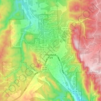
Nome: Mapa topográfico Woodland Park, altitude, relevo.
Altitude média: 2.652 m
Altitude mínima: 2.445 m
Altitude máxima: 2.884 m
The area is characterized by the abundance of large granite rocks and alpine meadows, as well as its consistently high elevation ranging between 8,200 and 10,000 feet above sea level. The climate is considered arid which causes the surrounding forests to become very dry, posing a significant fire threat in combination with a large proportion of lightning strikes and high mountain winds. Fire restrictions are common.
Outros mapas topográficos
Clique em um mapa para visualizar sua topografia, sua altitude e seu relevo.
Florissant Fossil Beds National Monument
United States > Colorado > Teller County
Florissant Fossil Beds National Monument, County Road 121, Teller County, Colorado, 80816, United States
Altitude média: 2.616 m
Florissant
United States > Colorado > Teller County
Florissant, Teller County, Colorado, United States
Altitude média: 2.556 m
Divide
United States > Colorado > Teller County
Divide, Teller County, Colorado, United States
Altitude média: 2.796 m
Cripple Creek
United States > Colorado > Teller County
Cripple Creek, Teller County, Colorado, United States
Altitude média: 2.946 m