
Mapa topográfico Florissant Fossil Beds National Monument
Mapa interativo
Clique no mapa para exibir a altitude.
Florissant Fossil Beds National Monument
Early estimates of the elevation of the Florissant beds was determined to be between 300–900 meters, much lower than the modern elevation of 2,500-2,600 meters. However, more recent estimates that are based on paleoflora have put the elevation in the Eocene much higher. Ranges from 1,900 to 4,100 meters have been proposed. This would indicate that global climate change, rather than tectonic uplift, would be the main cause of changing environments in the area. The actual elevation of the Florissant area during the Eocene is still being determined. While most of the analysis using paleoflora has the area at a higher elevation than modern times, there is evidence that the elevation was as low as the earlier estimates.
Sobre este mapa
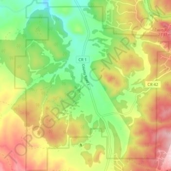
Nome: Mapa topográfico Florissant Fossil Beds National Monument, altitude, relevo.
Altitude média: 2.616 m
Altitude mínima: 2.494 m
Altitude máxima: 2.757 m
Outros mapas topográficos
Clique em um mapa para visualizar sua topografia, sua altitude e seu relevo.