
Mapa topográfico Gorham
Mapa interativo
Clique no mapa para exibir a altitude.
Sobre este mapa
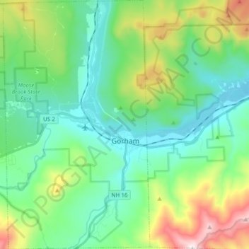
Nome: Mapa topográfico Gorham, altitude, relevo.
Local: Gorham, Coös County, New Hampshire, 03581, United States (44.33998 -71.24869 44.44987 -71.15793)
Altitude média: 477 m
Altitude mínima: 215 m
Altitude máxima: 1.214 m
The highest point in Gorham is along its western border, on a spur of Mount Madison, where the elevation reaches 3,030 feet (920 m) above sea level. While Gorham itself is surrounded by larger mountains, a small prominent peak within the town is 2,400-foot (730 m) high Pine Mountain.
Outros mapas topográficos
Clique em um mapa para visualizar sua topografia, sua altitude e seu relevo.
Mount Washington
United States > New Hampshire > Coos County
Mount Washington, Coös County, New Hampshire, United States
Altitude média: 1.568 m
Millsfield
United States > New Hampshire > Coos County
Millsfield, Coös County, New Hampshire, United States
Altitude média: 583 m
Jefferson Highland
United States > New Hampshire > Coos County > Jefferson
Jefferson Highland, Jefferson, Coös County, New Hampshire, 03583, United States
Altitude média: 451 m
Jefferson
United States > New Hampshire > Coos County
Jefferson, Coös County, New Hampshire, 03583, United States
Altitude média: 493 m
Blake Islands
United States > New Hampshire > Coos County > Errol
Blake Islands, Errol, Coös County, New Hampshire, United States
Altitude média: 530 m
Pittsburg
United States > New Hampshire > Coos County
Pittsburg, Coös County, New Hampshire, United States
Altitude média: 522 m
Glen House
United States > New Hampshire > Coos County
Glen House, Green's Grant, Coos County, New Hampshire, United States
Altitude média: 647 m
Dummer
United States > New Hampshire > Coos County
Dummer, Coös County, New Hampshire, United States
Altitude média: 419 m
Fabyan
United States > New Hampshire > Coos County > Carroll
Fabyan, Carroll, Coos County, New Hampshire, 03575, United States
Altitude média: 590 m
Lake Francis
United States > New Hampshire > Coos County > Clarksville
Lake Francis, Clarksville, Coos County, New Hampshire, United States
Altitude média: 498 m
Bretton Woods
United States > New Hampshire > Coos County > Carroll
Bretton Woods, Carroll, Coös County, New Hampshire, 03575, United States
Altitude média: 577 m
Mount Pisgah
United States > New Hampshire > Coos County > Clarksville
Mount Pisgah, Clarksville, Coos County, New Hampshire, United States
Altitude média: 735 m
Sugar Mountain
United States > New Hampshire > Coos County > Gorham
Sugar Mountain, Gorham, Coos County, New Hampshire, United States
Altitude média: 607 m
Whitefield
United States > New Hampshire > Coos County
Whitefield, Coös County, New Hampshire, United States
Altitude média: 365 m
Errol
United States > New Hampshire > Coos County
Errol, Coös County, New Hampshire, United States
Altitude média: 453 m
Stewartstown
United States > New Hampshire > Coos County
Stewartstown, Coös County, New Hampshire, 03597, United States
Altitude média: 485 m