
Mapa topográfico Mount Washington
Mapa interativo
Clique no mapa para exibir a altitude.
Sobre este mapa
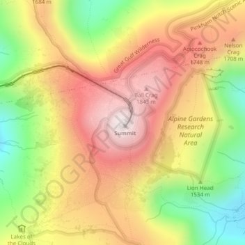
Nome: Mapa topográfico Mount Washington, altitude, relevo.
Local: Mount Washington, Coös County, New Hampshire, United States (44.27044 -71.30335 44.27054 -71.30325)
Altitude média: 1.568 m
Altitude mínima: 1.161 m
Altitude máxima: 1.911 m
Mount Washington, also known as Agiocochook, is an ultra-prominent mountain in the state of New Hampshire. It is the highest peak in the Northeastern United States at 6,288.2 ft (1,916.6 m) and the most topographically prominent mountain east of the Mississippi River.
Outros mapas topográficos
Clique em um mapa para visualizar sua topografia, sua altitude e seu relevo.
Millsfield
United States > New Hampshire > Coos County
Millsfield, Coös County, New Hampshire, United States
Altitude média: 583 m
Jefferson Highland
United States > New Hampshire > Coos County > Jefferson
Jefferson Highland, Jefferson, Coös County, New Hampshire, 03583, United States
Altitude média: 451 m
Jefferson
United States > New Hampshire > Coos County
Jefferson, Coös County, New Hampshire, 03583, United States
Altitude média: 493 m
Blake Islands
United States > New Hampshire > Coos County > Errol
Blake Islands, Errol, Coös County, New Hampshire, United States
Altitude média: 530 m
Pittsburg
United States > New Hampshire > Coos County
Pittsburg, Coös County, New Hampshire, United States
Altitude média: 522 m
Dummer
United States > New Hampshire > Coos County
Dummer, Coös County, New Hampshire, United States
Altitude média: 419 m
Glen House
United States > New Hampshire > Coos County
Glen House, Green's Grant, Coos County, New Hampshire, United States
Altitude média: 647 m
Fabyan
United States > New Hampshire > Coos County > Carroll
Fabyan, Carroll, Coos County, New Hampshire, 03575, United States
Altitude média: 590 m
Lake Francis
United States > New Hampshire > Coos County > Clarksville
Lake Francis, Clarksville, Coos County, New Hampshire, United States
Altitude média: 498 m
Bretton Woods
United States > New Hampshire > Coos County > Carroll
Bretton Woods, Carroll, Coös County, New Hampshire, 03575, United States
Altitude média: 577 m
Mount Pisgah
United States > New Hampshire > Coos County > Clarksville
Mount Pisgah, Clarksville, Coos County, New Hampshire, United States
Altitude média: 735 m
Sugar Mountain
United States > New Hampshire > Coos County > Gorham
Sugar Mountain, Gorham, Coos County, New Hampshire, United States
Altitude média: 607 m
Gorham
United States > New Hampshire > Coos County
Gorham, Coös County, New Hampshire, 03581, United States
Altitude média: 477 m
Whitefield
United States > New Hampshire > Coos County
Whitefield, Coös County, New Hampshire, United States
Altitude média: 365 m
Errol
United States > New Hampshire > Coos County
Errol, Coös County, New Hampshire, United States
Altitude média: 453 m
Stewartstown
United States > New Hampshire > Coos County
Stewartstown, Coös County, New Hampshire, 03597, United States
Altitude média: 485 m