
Faça uma doação
Mapa topográfico Port de Pollença
Clique no mapa para exibir a altitude.
Faça uma doação
Sobre este mapa
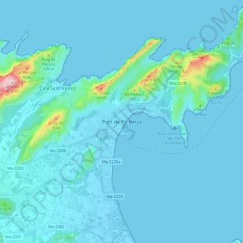
Nome: Mapa topográfico Port de Pollença, altitude, relevo.
Altitude média: 41 m
Altitude mínima: -2 m
Altitude máxima: 336 m
Faça uma doação
Outros mapas topográficos
Clique em um mapa para visualizar sua topografia, sua altitude e seu relevo.
Serra de Tramuntana
Spain > Balearic Islands > Serra de Tramuntana
The climate in the Tramuntana Range is significantly wetter than the rest of the island, recording as much as 1507 mm (59.3 inches) of precipitation per year, in comparison with some other parts of the island where annual rainfall is less than 400mm (15 inch). It is also cooler due to the altitude, and a few…
Altitude média: 175 m
Faça uma doação
Faça uma doação
Calvià
Spain > Balearic Islands > Serra de Tramuntana
Calvià first appears in history as a village 2,000 years BCE, although the area was first populated in the Neolithic Era. Later, sailors coming from the east stopped in the Balearics on their way to the Iberian Peninsula, where they sought metals. They came from Italy, from other Mediterranean islands, and…
Altitude média: 134 m
Faça uma doação
Serra de Tramuntana
Spain > Balearic Islands > Serra de Tramuntana
The climate in the Tramuntana Range is significantly wetter than the rest of the island, recording as much as 1507 mm (59.3 inches) of precipitation per year, in comparison with some other parts of the island where annual rainfall is less than 400mm (15 inch). It is also cooler due to the altitude, and a few…
Altitude média: 175 m
Faça uma doação
Faça uma doação