
Mapa topográfico Serra de Tramuntana
Mapa interativo
Clique no mapa para exibir a altitude.
Sobre este mapa
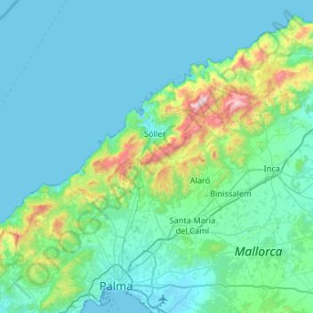
Nome: Mapa topográfico Serra de Tramuntana, altitude, relevo.
Local: Serra de Tramuntana, Balearic Islands, Spain (39.62579 2.44363 39.84761 2.96694)
Altitude média: 175 m
Altitude mínima: -1 m
Altitude máxima: 1.418 m
The climate in the Tramuntana Range is significantly wetter than the rest of the island, recording as much as 1507 mm (59.3 inches) of precipitation per year, in comparison with some other parts of the island where annual rainfall is less than 400mm (15 inch). It is also cooler due to the altitude, and a few days of snow are not unusual during winter.
Outros mapas topográficos
Clique em um mapa para visualizar sua topografia, sua altitude e seu relevo.
Pollença
Spain > Balearic Islands > Serra de Tramuntana
Pollença, Serra de Tramuntana, Balearic Islands, Spain
Altitude média: 115 m
Pollença
Spain > Balearic Islands > Serra de Tramuntana > Pollença > Pollença
Pollença, Serra de Tramuntana, Balearic Islands, 07460, Spain
Altitude média: 156 m