
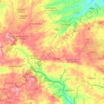
Mapa topográfico Tinchebray-Bocage
Mapa interativo
Clique no mapa para exibir a altitude.
Sobre este mapa
Nome: Mapa topográfico Tinchebray-Bocage, altitude, relevo.
Altitude média: 256 m
Altitude mínima: 130 m
Altitude máxima: 360 m
Outros mapas topográficos
Clique em um mapa para visualizar sua topografia, sua altitude e seu relevo.
Tinchebray
France > Normandy > Orne > Tinchebray-Bocage
Tinchebray, Tinchebray-Bocage, Argentan, Orne, Normandy, Metropolitan France, 61800, France
Altitude média: 238 m
Neuvy-au-Houlme
Neuvy-au-Houlme, Argentan, Orne, Normandy, Metropolitan France, 61210, France
Altitude média: 192 m
Saint-Langis-lès-Mortagne
France > Normandy > Orne > Saint-Langis-lès-Mortagne
Saint-Langis-lès-Mortagne, Mortagne-au-Perche, Orne, Normandy, Metropolitan France, 61400, France
Altitude média: 206 m
Les Monts-d'Andaine
France > Normandy > Orne > Les Monts-d'Andaine
Les Monts-d'Andaine, Argentan, Orne, Normandy, Metropolitan France, 61600, France
Altitude média: 244 m
La Perrière
France > Normandy > Orne > Belforêt-en-Perche
La Perrière, Belforêt-en-Perche, Mortagne-au-Perche, Orne, Normandy, Metropolitan France, 61360, France
Altitude média: 174 m
Chambois
France > Normandy > Orne > Gouffern en Auge
Chambois, Gouffern en Auge, Argentan, Orne, Normandy, Metropolitan France, 61160, France
Altitude média: 115 m
Lonlay-l'Abbaye
Lonlay-l'Abbaye, Argentan, Orne, Normandy, Metropolitan France, 61700, France
Altitude média: 214 m