Geolocalizar

Mapa topográfico Argentan

Mapa interativo

Clique no mapa para exibir a altitude.

Sobre este mapa

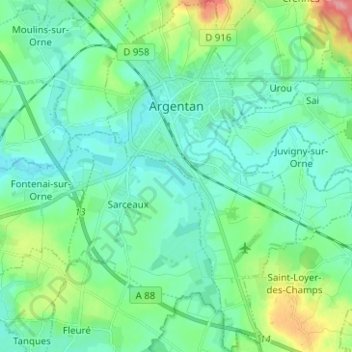
Nome: Mapa topográfico Argentan, altitude, relevo.

Local: Argentan, Orne, Normandy, Metropolitan France, 61200, France (48.68503 -0.04796 48.76762 0.02200)

Altitude média: 170 m

Altitude mínima: 149 m

Altitude máxima: 244 m

Outros mapas topográficos

Clique em um mapa para visualizar sua topografia, sua altitude e seu relevo.

Tinchebray

France > Normandy > Orne > Tinchebray-Bocage

Tinchebray, Tinchebray-Bocage, Argentan, Orne, Normandy, Metropolitan France, 61800, France

Altitude média: 238 m

Neuvy-au-Houlme

France > Normandy > Orne

Neuvy-au-Houlme, Argentan, Orne, Normandy, Metropolitan France, 61210, France

Altitude média: 192 m

Saint-Langis-lès-Mortagne

France > Normandy > Orne > Saint-Langis-lès-Mortagne

Saint-Langis-lès-Mortagne, Mortagne-au-Perche, Orne, Normandy, Metropolitan France, 61400, France

Altitude média: 206 m

Macé

France > Normandy > Orne > Macé

Macé, Alençon, Orne, Normandy, Metropolitan France, 61500, France

Altitude média: 182 m

Les Monts-d'Andaine

France > Normandy > Orne > Les Monts-d'Andaine

Les Monts-d'Andaine, Argentan, Orne, Normandy, Metropolitan France, 61600, France

Altitude média: 244 m

La Perrière

France > Normandy > Orne > Belforêt-en-Perche

La Perrière, Belforêt-en-Perche, Mortagne-au-Perche, Orne, Normandy, Metropolitan France, 61360, France

Altitude média: 174 m

Chanu

France > Normandy > Orne > Chanu

Chanu, Argentan, Orne, Normandy, Metropolitan France, 61800, France

Altitude média: 276 m

Tinchebray-Bocage

France > Normandy > Orne

Tinchebray-Bocage, Argentan, Orne, Normandy, Metropolitan France, 61800, France

Altitude média: 256 m

Chambois

France > Normandy > Orne > Gouffern en Auge

Chambois, Gouffern en Auge, Argentan, Orne, Normandy, Metropolitan France, 61160, France

Altitude média: 115 m

Lonlay-l'Abbaye

France > Normandy > Orne

Lonlay-l'Abbaye, Argentan, Orne, Normandy, Metropolitan France, 61700, France

Altitude média: 214 m