
Mapa topográfico Apeldoorn
Mapa interativo
Clique no mapa para exibir a altitude.
Sobre este mapa
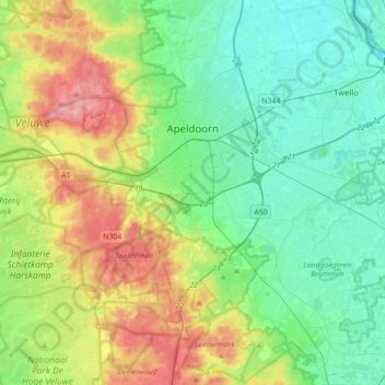
Nome: Mapa topográfico Apeldoorn, altitude, relevo.
Local: Apeldoorn, Gelderland, Netherlands (52.07334 5.72639 52.28567 6.07848)
Altitude média: 36 m
Altitude mínima: 1 m
Altitude máxima: 110 m
In 1689 William III became King of England, Scotland and Ireland and this elevation of his position and power brought an enlargement of Het Loo in its wake. Between 1691 and 1694 the colonnades which linked the corps de logis to the wings on either side were replaced by four pavilions. These pavilions contained the new apartments of William III and Mary II, a new Dining Room, a Long Gallery and a Chapel. Queen Mary did not return to the Netherlands after 1689 and never saw the enlargement.
Outros mapas topográficos
Clique em um mapa para visualizar sua topografia, sua altitude e seu relevo.
Afgedamde Maas
Netherlands > Gelderland > Poederoijen
Afgedamde Maas, Poederoijen, Zaltbommel, Gelderland, Netherlands
Altitude média: 2 m
Wageningen
Netherlands > Gelderland > Wageningen
Wageningen, Gelderland, Netherlands
Altitude média: 14 m
Kops Plateau
Netherlands > Gelderland > Nijmegen
Kops Plateau, Nijmegen, Gelderland, Netherlands, 6574 AR, Netherlands
Altitude média: 36 m
Beekbergen
Beekbergen, Apeldoorn, Gelderland, Netherlands
Altitude média: 47 m
Nationaal Park De Hoge Veluwe
Netherlands > Gelderland > Hoenderloo
Nationaal Park De Hoge Veluwe, Hoenderloo, Ede, Gelderland, Netherlands
Altitude média: 41 m
Garderen
Netherlands > Gelderland > Garderen
Garderen, Barneveld, Gelderland, Netherlands
Altitude média: 34 m
Tonden
Netherlands > Gelderland > Tonden > Tonden
Tonden, Brummen, Gelderland, Netherlands, 6975 AH, Netherlands
Altitude média: 9 m
Leuvenheim
Netherlands > Gelderland > Leuvenheim
Leuvenheim, Brummen, Gelderland, Netherlands
Altitude média: 10 m
Warm
Netherlands > Gelderland > Etten > Warm
Warm, Etten, Oude IJsselstreek, Gelderland, Netherlands, 7075 EL, Netherlands
Altitude média: 14 m
Bemmel
Netherlands > Gelderland > Bemmel
Bemmel, Lingewaard, Gelderland, Netherlands
Altitude média: 10 m
Stadscentrum
Netherlands > Gelderland > Nijmegen
Stadscentrum, Nijmegen-Centrum, Nijmegen, Gelderland, Netherlands
Altitude média: 21 m
Lobith
Netherlands > Gelderland > Lobith
Lobith, Zevenaar, Gelderland, Netherlands
Altitude média: 13 m
's-Heerenberg
Netherlands > Gelderland > Montferland > 's-Heerenberg
's-Heerenberg, Montferland, Gelderland, Netherlands
Altitude média: 22 m
Arnhem
Netherlands > Gelderland > Arnhem
Arnhem, Gelderland, Netherlands, 6811AL, Netherlands
Altitude média: 24 m
Oostereng
Netherlands > Gelderland > Wageningen > Wageningen-Hoog
Oostereng, Everlaan, Wageningen-Hoog, Wageningen, Gelderland, Netherlands, 6705DK, Netherlands
Altitude média: 29 m
Rhienderen
Netherlands > Gelderland > Brummen > Rhienderen
Rhienderen, Brummen, Gelderland, Netherlands, 6971, Netherlands
Altitude média: 9 m
West Maas en Waal
West Maas en Waal, Gelderland, Netherlands
Altitude média: 6 m
Nijmegen
Netherlands > Gelderland > Nijmegen
Nijmegen, Gelderland, Netherlands, 6511KA, Netherlands
Altitude média: 16 m
Lathum
Netherlands > Gelderland > Lathum
Lathum, Zevenaar, Gelderland, Netherlands
Altitude média: 16 m
Bradaal
Netherlands > Gelderland > Culemborg > Bradaal
Bradaal, Culemborg, Gelderland, Netherlands, 4107LN, Netherlands
Altitude média: 1 m
Groesbeek
Groesbeek, Berg en Dal, Gelderland, Netherlands
Altitude média: 41 m