
Faça uma doação
Mapa topográfico Ponce
Clique no mapa para exibir a altitude.
Faça uma doação
Ponce
Elevations include Cerro de Punta at 4,390 feet (1,338 m), the highest in Puerto Rico, located in Barrio Anón in the territory of the municipality of Ponce. Mount Jayuya, at 4,314 feet (1,315 m) is located on the boundary between Barrio Anón and Barrio Saliente in Jayuya. Cerro Maravilla, at nearly 3,970 feet (1,210 m) above sea level, is located to the east of Barrio Anón. There are many other mountains at lower elevations in the municipality, such as the Montes Llanos ridge and Mount Diablo, at 2,231 feet (680 m) and Mount Marueño, at 2,100 feet (640 m), and Pinto Peak, among others. Part of the Toro Negro Forest is located in Barrio Anón. Coastal promontories include Cuchara, Peñoncillo, Carnero, and Cabullón points. Fifty-six percent of the municipality consists of slopes 10 degrees or greater.
Faça uma doação
Sobre este mapa
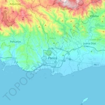
Nome: Mapa topográfico Ponce, altitude, relevo.
Local: Ponce, Puerto Rico, United States (17.88132 -66.69912 18.17232 -66.50955)
Altitude média: 211 m
Altitude mínima: -1 m
Altitude máxima: 1.298 m
Faça uma doação
Outros mapas topográficos
Clique em um mapa para visualizar sua topografia, sua altitude e seu relevo.
Faça uma doação
Faça uma doação
Faça uma doação
Isla de Mona
United States > Puerto Rico > Mayagüez
Mona is a mainly flat plateau surrounded by sea cliffs. It is composed of dolomite and limestone with many caves found throughout. With an arid climate and untouched by human development, many endemic species inhabit the island, such as the Mona ground iguana (Cyclura cornuta stejnegeri). Its topography,…
Altitude média: 26 m
Faça uma doação
Faça uma doação
Faça uma doação
Faça uma doação
Faça uma doação
Faça uma doação
Mayagüez
United States > Puerto Rico > Mayagüez
Mayagüez has a tropical monsoon climate (Köppen climate classification Am). The city has the most extreme weather of the island. The high frequency of severe storms in the summer can produce strong winds, floods, waterspouts, and sometimes hail and even tornadoes. The average annual temperature is 75 °F (24…
Altitude média: 93 m
Faça uma doação
Cayey
United States > Puerto Rico > Cayey
Cayey's climate is humid, rainy and mild compared to lower-elevation areas of the island, the area of the town is nearly 1,500 feet (460 m) high, so the climate is subtropical high. In summer average high Temperatures are around 82 °F to 88 °F and 70 °F to 78 °F in winter, and low around 68 °F to 72 °F…
Altitude média: 489 m
Gozalandia Waterfall
United States > Puerto Rico > San Sebastián > San Sebastián
Altitude média: 176 m
Faça uma doação
Faça uma doação
Faça uma doação
Faça uma doação
Ceiba
United States > Puerto Rico > Ceiba
The highest point in the municipality is Pico del Oeste in the Sierra de Luquillo at 3,346 feet (1,020 m) of elevation.
Altitude média: 50 m
Faça uma doação
Faça uma doação
Cerro de Punta
United States > Puerto Rico > Ponce
The mountain is part of the Cordillera Central and is located on the border between the municipalities of Jayuya and Ponce. The access road to the point closest to the highest elevation is from the municipality of Jayuya. It is part of the Toro Negro Forest Reserve, and it has been described as "an alpine…
Altitude média: 1.021 m
Faça uma doação
Villalba
United States > Puerto Rico > Villalba > Villalba
Villalba is located in the central region of Puerto Rico, on a valley in the Cordillera Central. The highest point in the municipality is Cerro El Bolo at 3,526 feet (1,075 m) of elevation.
Altitude média: 406 m
Faça uma doação
Faça uma doação
Faça uma doação