
Faça uma doação
Mapa topográfico Mayagüez
Clique no mapa para exibir a altitude.
Faça uma doação
Mayagüez
Mayagüez has a tropical monsoon climate (Köppen climate classification Am). The city has the most extreme weather of the island. The high frequency of severe storms in the summer can produce strong winds, floods, waterspouts, and sometimes hail and even tornadoes. The average annual temperature is 75 °F (24 °C). Winter is usually quite dry and cool, with temperatures between 82 °F (28 °C) and 55 °F (13 °C). Summer is usually very hot and humid, with temperatures reaching 95 °F (35 °C), with heat index of up to 115 °F. From May to October, most evenings experience severe thunderstorms, due to heat, humidity and the topography of the area.
Faça uma doação
Sobre este mapa
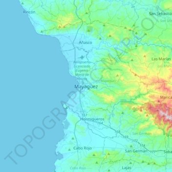
Nome: Mapa topográfico Mayagüez, altitude, relevo.
Local: Mayagüez, Puerto Rico, 00682, United States (18.04112 -67.29911 18.36112 -66.97911)
Altitude média: 93 m
Altitude mínima: 0 m
Altitude máxima: 878 m
Faça uma doação
Outros mapas topográficos
Clique em um mapa para visualizar sua topografia, sua altitude e seu relevo.
Isla de Mona
United States > Puerto Rico > Mayagüez
Mona is a mainly flat plateau surrounded by sea cliffs. It is composed of dolomite and limestone with many caves found throughout. With an arid climate and untouched by human development, many endemic species inhabit the island, such as the Mona ground iguana (Cyclura cornuta stejnegeri). Its topography,…
Altitude média: 26 m
Desecheo Island
United States > Puerto Rico > Mayagüez
Desecheo, which has no known bodies of surface water, reaches a maximum elevation of 715 ft (218 m) and has an annual precipitation, on average, of 40.15 in (1020 mm). The lack of surface water limits its flora to thorny shrubs, small trees, weeds and various cacti, including the endangered higo chumbo…
Altitude média: 9 m