
Faça uma doação
Mapa topográfico Port Arthur
Clique no mapa para exibir a altitude.
Faça uma doação
Port Arthur
Port Arthur sits in a low-lying coastal area of the Gulf Coast, characterized by its flat, marshy terrain. The city is located at an average elevation of just 8 feet (2 meters) above sea level, with parts of the surrounding region even closer to sea level. Its topography is dominated by wetlands, tidal marshes, and the estuaries of Sabine Lake and the Neches River, with vast stretches of flat, low-lying land interspersed by canals and small bayous. This terrain makes the area particularly susceptible to flooding, especially during storm surges from hurricanes or heavy rainfall. The region is also known for its proximity to the Gulf of Mexico, influencing its coastal landscape with sandy stretches and the presence of islands like Pleasure Island.
Faça uma doação
Sobre este mapa
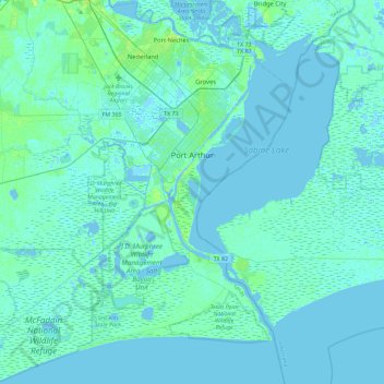
Nome: Mapa topográfico Port Arthur, altitude, relevo.
Local: Port Arthur, Jefferson County, Texas, United States (29.63312 -94.10662 30.03235 -93.81135)
Altitude média: 2 m
Altitude mínima: -5 m
Altitude máxima: 14 m
Faça uma doação
Outros mapas topográficos
Clique em um mapa para visualizar sua topografia, sua altitude e seu relevo.