
Faça uma doação
Mapa topográfico Sky Valley
Clique no mapa para exibir a altitude.
Faça uma doação
Sky Valley
According to the United States Census Bureau, the city has a total area of 3.0 square miles (7.8 km2), all land. The elevation of the valley floor is approximately 3100 feet above sea level, while areas within the city limits on the slopes of Rabun Bald exceed 4200 feet. Sky Valley is Georgia's highest incorporated city and one of the highest municipalities in the eastern United States.
Faça uma doação
Sobre este mapa
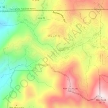
Nome: Mapa topográfico Sky Valley, altitude, relevo.
Local: Sky Valley, Rabun County, Georgia, United States (34.96659 -83.35311 34.99589 -83.31062)
Altitude média: 973 m
Altitude mínima: 652 m
Altitude máxima: 1.275 m
Faça uma doação
Outros mapas topográficos
Clique em um mapa para visualizar sua topografia, sua altitude e seu relevo.
Faça uma doação
Clayton
United States > Georgia > Rabun County > Clayton
According to the United States Census Bureau, the city has a total area of 3.1 square miles (8.0 km2), all of it land. The elevation of Clayton's downtown area is 1,925 feet (587 m). A number of hilltops within the city limits exceed 2,200 feet.
Altitude média: 634 m