
Faça uma doação
Mapa topográfico Gatineau
Clique no mapa para exibir a altitude.
Faça uma doação
Gatineau
Gatineau is located in southwestern Quebec, on the northern bank of the Gatineau River. It is situated at an elevation of around 50 m (164.042 ft) The Gatineau Hills are the foothills of the Laurentian Mountains and located in the region. It is also the location of the second largest urban park in the world. They supply great skiing and snowboarding opportunities within minutes of the city. Gatineau is situated close to where the Canadian shield and the Saint Lawrence Lowlands intersect. The area has several major fault lines and small earthquakes do occur somewhat regularly, on average, there are at least one earthquake of intensity III or higher once every three years in Ottawa-Gatineau. The most memorable being the 2010 Central Canada earthquake that occurred in Quebec. The epicentre was situated approximately 56 kilometres (35 mi) north of Ottawa, Ontario, in the municipality of Val-des-Bois, Quebec.
Faça uma doação
Sobre este mapa
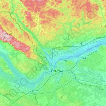
Nome: Mapa topográfico Gatineau, altitude, relevo.
Local: Gatineau, Outaouais, Quebec, Canada (45.37238 -75.90835 45.59912 -75.34423)
Altitude média: 127 m
Altitude mínima: 39 m
Altitude máxima: 409 m
Faça uma doação
Outros mapas topográficos
Clique em um mapa para visualizar sua topografia, sua altitude e seu relevo.
Mont Saint-Bruno
Canada > Quebec > Urban agglomeration of Longueuil > Saint-Bruno-de-Montarville
Altitude média: 85 m
Mount Royal
Canada > Quebec > Urban agglomeration of Montreal > Montreal
The hill is part of the Monteregian Hills situated between the Laurentians and the Appalachian Mountains. It gave its Latin name, Mons Regius, to the Monteregian chain. The hill consists of three peaks: Colline de la Croix (or Mont Royal proper) at 233 m (764 ft), Colline d'Outremont (or Mount Murray, in the…
Altitude média: 111 m
Faça uma doação
Mount Royal Park
Canada > Quebec > Urban agglomeration of Montreal > Montreal
The mountain is part of the Monteregian Hills situated between the Laurentians and the Appalachian Mountains. It gave its Latin name, Mons Regius, to the Monteregian chain. The mountain consists of three peaks: Colline de la Croix (or Mont Royal proper) at 233 m (764 ft), Colline d'Outremont (or Mount Murray,…
Altitude média: 110 m
Faça uma doação
Faça uma doação
Faça uma doação
Saint Helen's Island
Canada > Quebec > Urban agglomeration of Montreal > Montreal
Altitude média: 15 m
Faça uma doação
Quebec
Canada > Quebec > Urban agglomeration of Québec
Quebec City was built on the north bank of the Saint Lawrence River, where it narrows and meets the mouth of the Saint-Charles River. Old Quebec is located on top and at the foot of Cap-Diamant, which is on the eastern edge of a plateau called the promontory of Quebec (Quebec hill). Because of this topographic…
Altitude média: 100 m
Faça uma doação
Faça uma doação
Faça uma doação
Faça uma doação
Faça uma doação
Faça uma doação
Chisasibi (partie Inuit)
Canada > Quebec > Jamésie > Chisasibi (Land) > Chisasibi
Altitude média: 11 m
Faça uma doação
Faça uma doação
Faça uma doação
Faça uma doação
Faça uma doação
Faça uma doação
Faça uma doação
Faça uma doação
Faça uma doação
Scouts Canada - Lake Lovering Scouts Reserve
Canada > Quebec > Memphrémagog > Magog
Altitude média: 260 m
Madeleine-Centre
Canada > Quebec > La Haute-Gaspésie > Sainte-Madeleine-de-la-Rivière-Madeleine
Altitude média: 72 m
Faça uma doação
Magdalen Islands
Canada > Quebec > Urban agglomeration of Les Îles-de-la-Madeleine
Altitude média: 1 m
Faça uma doação
Faça uma doação
Rivière-la-Madeleine
Canada > Quebec > La Haute-Gaspésie > Sainte-Madeleine-de-la-Rivière-Madeleine
Altitude média: 46 m
Gault Nature Reserve
Canada > Quebec > La Vallée-du-Richelieu > Mont-Saint-Hilaire
Altitude média: 189 m
Faça uma doação
Faça uma doação