
Mapa topográfico Mount Royal
Clique no mapa para exibir a altitude.
Mount Royal
The hill is part of the Monteregian Hills situated between the Laurentians and the Appalachian Mountains. It gave its Latin name, Mons Regius, to the Monteregian chain. The hill consists of three peaks: Colline de la Croix (or Mont Royal proper) at 233 m (764 ft), Colline d'Outremont (or Mount Murray, in the borough of Outremont) at 211 m (692 ft), and Westmount Summit at 201 m (659 ft) elevation above mean sea level.
Sobre este mapa
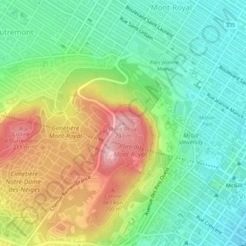
Nome: Mapa topográfico Mount Royal, altitude, relevo.
Altitude média: 111 m
Altitude mínima: 35 m
Altitude máxima: 232 m
Outros mapas topográficos
Clique em um mapa para visualizar sua topografia, sua altitude e seu relevo.
Rivière des Prairies
Canada > Quebec > Urban agglomeration of Montreal > Montreal
Altitude média: 34 m
Parc de la Rive-Boisée
Canada > Quebec > Urban agglomeration of Montreal > Montreal
Altitude média: 29 m
Rivière des Prairies
Canada > Quebec > Urban agglomeration of Montreal > Montreal
Altitude média: 36 m
Rosemont–La Petite-Patrie
Canada > Quebec > Urban agglomeration of Montreal > Montreal
Altitude média: 50 m
Parc Léon-Provancher
Canada > Quebec > Urban agglomeration of Montreal > Montreal
Altitude média: 53 m
Saint Helen's Island
Canada > Quebec > Urban agglomeration of Montreal > Montreal
Altitude média: 15 m
Le Plateau-Mont-Royal
Canada > Quebec > Urban agglomeration of Montreal > Montreal
Altitude média: 70 m
Parc-nature du Bois-de-Liesse
Canada > Quebec > Urban agglomeration of Montreal > Montreal
Altitude média: 28 m
Parc-nature de la Pointe-aux-Prairies
Canada > Quebec > Urban agglomeration of Montreal > Montreal
Altitude média: 12 m