
Mapa topográfico Buchenlohe
Mapa interativo
Clique no mapa para exibir a altitude.
Sobre este mapa
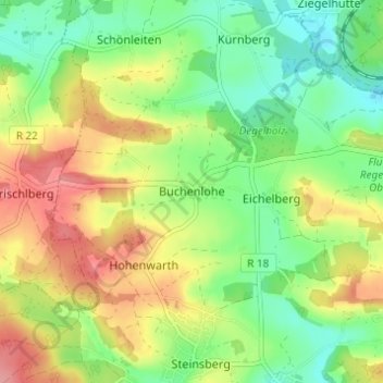
Nome: Mapa topográfico Buchenlohe, altitude, relevo.
Altitude média: 389 m
Altitude mínima: 347 m
Altitude máxima: 444 m
Outros mapas topográficos
Clique em um mapa para visualizar sua topografia, sua altitude e seu relevo.
Eitlbrunn
Deutschland > Bayern > Landkreis Regensburg > Regenstauf
Eitlbrunn, Regenstauf, Landkreis Regensburg, Bayern, 93128, Deutschland
Altitude média: 386 m
Neuhaus
Deutschland > Bayern > Landkreis Regensburg > Regenstauf > Hagenau
Neuhaus, Hagenau, Regenstauf, Landkreis Regensburg, Bayern, 93128, Deutschland
Altitude média: 365 m