
Obrigado por apoiar este site ❤️
Faça uma doação
Faça uma doação
Mapa topográfico Navsari
Clique no mapa para exibir a altitude.
Obrigado por apoiar este site ❤️
Faça uma doação
Faça uma doação
Navsari
Navsari is located at 20°57′N 72°56′E / 20.95°N 72.93°E / 20.95; 72.93. It has an average elevation of 9 metres or 30 feet above sea level. The city is located in southern Gujarat and is situated near the Purna River, within a few kilometers of the river's delta, which is west of the city and empties into the Gulf of Khambhat. The weather in Navsari is sunny from October to May, and rainy from June to September. The average maximum and minimum temperatures are 42 °C (107.6 °F) and 17 °C (62.6 °F) respectively. The average annual rainfall is 122 cm (48 in).
Obrigado por apoiar este site ❤️
Faça uma doação
Faça uma doação
Sobre este mapa
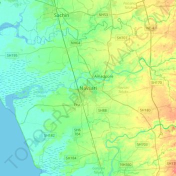
Nome: Mapa topográfico Navsari, altitude, relevo.
Altitude média: 14 m
Altitude mínima: -2 m
Altitude máxima: 45 m
Obrigado por apoiar este site ❤️
Faça uma doação
Faça uma doação