
Mapa topográfico Xiangning County
Mapa interativo
Clique no mapa para exibir a altitude.
Sobre este mapa
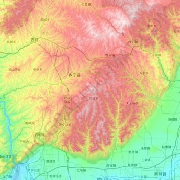
Nome: Mapa topográfico Xiangning County, altitude, relevo.
Local: Xiangning County, Linfen, Shanxi, China (35.68929 110.50663 36.14994 111.28696)
Altitude média: 977 m
Altitude mínima: 376 m
Altitude máxima: 1.804 m
The county is located in the Lüliang Mountains of the Loess Plateau, and has a largely hilly terrain with an average elevation of about 900 metres (3,000 ft). The county's highest point is Gaotian Mountain (Chinese: 高天山), which reaches 1,820.5 metres (5,973 ft) in altitude; the county's lowest point is along the banks of the Yellow River, at 385.1 metres (1,263 ft) in altitude.
Outros mapas topográficos
Clique em um mapa para visualizar sua topografia, sua altitude e seu relevo.
Qingxu County
China > Shanxi > Qingxu County
Qingxu County, Taiyuan City, Shanxi, China
Altitude média: 913 m
Gujiao City
China > Shanxi > Gujiao City
Gujiao City, Taiyuan City, Shanxi, China
Altitude média: 1.379 m
Taiyuan
China > Shanxi > Taiyuan > Sanqiao Subdistrict
Taiyuan, Sanqiao Subdistrict, Xinghualing District, Taiyuan City, Shanxi, 030002, China
Altitude média: 982 m