
Mapa topográfico Chatkal District
Mapa interativo
Clique no mapa para exibir a altitude.
Sobre este mapa
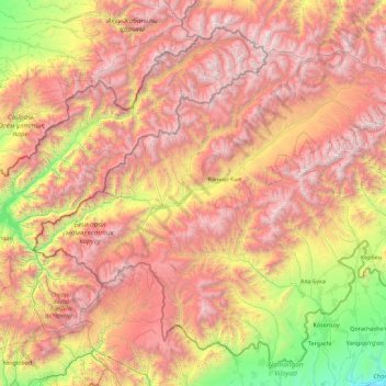
Nome: Mapa topográfico Chatkal District, altitude, relevo.
Local: Chatkal District, Jalal-Abad Region, Kyrgyzstan (41.20832 70.16896 42.21876 71.98111)
Altitude média: 2.327 m
Altitude mínima: 478 m
Altitude máxima: 4.444 m
The district occupies high-altitude Chatkal valley limited by Talas Ala-Too from north, Pskem Range from north-west and west, and Chatkal Range from south-east. In addition, the district includes a small area of south-east slope of the Chatkal Range facing Fergana Valley. Elevations of the terrain range from approximately 1500 m at Sumsar to 4503 m in the Chatkal range. Some other picks of the district reach altitudes of over 4000 meters. Chatkal valley is pear-shaped. The slope of Chatkal Range facing the valley is terraced. The terraces are dissected by deep canyons of Chatkal river's tributaries, characterized by snowfields and small glaciers in the upstreams. Chandalash Range extends in the central part of the district. Mountains occupy 96%, and vallies - 4% of the district.
Outros mapas topográficos
Clique em um mapa para visualizar sua topografia, sua altitude e seu relevo.
Жыгач-Коргон
Kyrgyzstan > Jalal-Abad Region > Suzak District
Жыгач-Коргон, Suzak District, Jalal-Abad Region, Kyrgyzstan
Altitude média: 978 m
Suzak
Kyrgyzstan > Jalal-Abad Region > Suzak
Suzak, Jalal-Abad Region, 721328, Kyrgyzstan
Altitude média: 722 m
Таш-Булак
Kyrgyzstan > Jalal-Abad Region > Таш-Булак
Таш-Булак, Jalal-Abad Region, Kyrgyzstan
Altitude média: 913 m
Сары-Таш
Kyrgyzstan > Jalal-Abad Region
Сары-Таш, Jalal-Abad Region, Kyrgyzstan
Altitude média: 2.231 m
Chatkal ridge
Kyrgyzstan > Jalal-Abad Region
Chatkal ridge, Jalal-Abad Region, Kyrgyzstan
Altitude média: 2.463 m
Suzak
Kyrgyzstan > Jalal-Abad Region
Suzak, Jalal-Abad Region, 721319, Kyrgyzstan
Altitude média: 730 m
Sary-Chelek
Kyrgyzstan > Jalal-Abad Region
Sary-Chelek, Jalal-Abad Region, Kyrgyzstan
Altitude média: 2.620 m