
Faça uma doação
Mapa topográfico Geneva
Clique no mapa para exibir a altitude.
Faça uma doação
Sobre este mapa
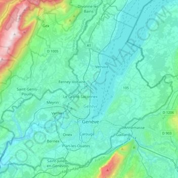
Nome: Mapa topográfico Geneva, altitude, relevo.
Local: Geneva, Switzerland (46.12855 5.95591 46.36457 6.31029)
Altitude média: 522 m
Altitude mínima: 342 m
Altitude máxima: 1.678 m
Faça uma doação
Outros mapas topográficos
Clique em um mapa para visualizar sua topografia, sua altitude e seu relevo.
Schloss Wittigkofen
Switzerland > Bern > Bern-Mittelland administrative district > Bern > Schloss Wittigkofen
Altitude média: 568 m
Kiental
Switzerland > Bern > Frutigen-Niedersimmental administrative district > Reichenbach im Kandertal
Altitude média: 1.363 m
Zermatt
Switzerland > Wallis > Visp > Zermatt > Zermatt
It lies at the upper end of Mattertal at an elevation of 1,620 m (5,310 ft), at the foot of Switzerland's highest peaks. It lies about 10 km (6.2 mi) from the over 3,292 m (10,801 ft) high Theodul Pass bordering Italy. Zermatt is the southernmost commune of the German Sprachraum.
Altitude média: 2.469 m
Faça uma doação