
Faça uma doação
Mapa topográfico Blairsville
Clique no mapa para exibir a altitude.
Faça uma doação
Blairsville
Blairsville, Georgia, is situated in the picturesque Appalachian Mountains, characterized by a varied topography that includes rolling hills, lush valleys, and prominent mountain ridges. The elevation of the town itself is approximately 1,800 feet, providing breathtaking views of the surrounding landscape. The area is intersected by numerous creeks and streams, which contribute to the rich biodiversity and vibrant ecosystems. Nearby, the towering peaks of the Blue Ridge Mountains can reach elevations over 4,000 feet, creating a dramatic backdrop and offering numerous hiking trails that meander through dense forests and alongside serene lakes. This mountainous terrain, combined with its fertile valleys, makes Blairsville a striking example of North Georgia's natural beauty, appealing to outdoor enthusiasts and nature lovers alike.
Faça uma doação
Sobre este mapa
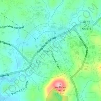
Nome: Mapa topográfico Blairsville, altitude, relevo.
Local: Blairsville, Union County, Georgia, United States (34.86877 -83.96754 34.88341 -83.93990)
Altitude média: 587 m
Altitude mínima: 542 m
Altitude máxima: 726 m
Faça uma doação
Outros mapas topográficos
Clique em um mapa para visualizar sua topografia, sua altitude e seu relevo.
Blood Mountain
United States > Georgia > Union County
Blood Mountain is the highest peak on the Georgia section of the Appalachian Trail and the sixth-tallest mountain in Georgia, with an elevation of 4,458 feet (1,359 m). It is located on the border of Lumpkin County with Union County and is within the boundaries of the Chattahoochee National Forest and the…
Altitude média: 1.048 m
Faça uma doação