Geolocalizar

Mapa topográfico Durrow

Mapa interativo

Clique no mapa para exibir a altitude.

Sobre este mapa

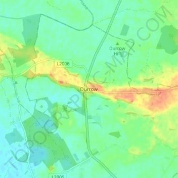
Nome: Mapa topográfico Durrow, altitude, relevo.

Local: Durrow, The Municipal District of Tullamore, County Offaly, Leinster, R35 X865, Ireland (53.31037 -7.53066 53.35037 -7.49066)

Altitude média: 66 m

Altitude mínima: 53 m

Altitude máxima: 91 m

Outros mapas topográficos

Clique em um mapa para visualizar sua topografia, sua altitude e seu relevo.

Moorock

Ireland > County Offaly

Moorock, Ballycumber ED, The Municipal District of Tullamore, County Offaly, Leinster, Ireland

Altitude média: 64 m

Mount Lucas

Ireland > County Offaly

Mount Lucas, Esker ED, The Municipal District of Edenderry, County Offaly, Leinster, R35 XW10, Ireland

Altitude média: 76 m

Tullamore

Ireland > County Offaly

Tullamore, The Municipal District of Tullamore, County Offaly, Leinster, Ireland

Altitude média: 65 m

Shannonbridge

Ireland > County Offaly

Shannonbridge, Shannonbridge ED, The Municipal District of Birr, County Offaly, Leinster, Ireland

Altitude média: 38 m

Daingean

Ireland > County Offaly

Daingean, Daingean ED, The Municipal District of Edenderry, County Offaly, Leinster, Ireland

Altitude média: 82 m

The Municipal District of Edenderry

Ireland > County Offaly

The Municipal District of Edenderry, County Offaly, Leinster, Ireland

Altitude média: 80 m

Rath

Ireland > County Offaly

Rath, Drumcullen ED, The Municipal District of Birr, County Offaly, Leinster, Ireland

Altitude média: 66 m

Brosna

Ireland > County Offaly

Brosna, County Offaly, Leinster, Ireland

Altitude média: 69 m

Ballycommon

Ireland > County Offaly

Ballycommon, The Municipal District of Edenderry, County Offaly, Leinster, Ireland

Altitude média: 80 m

Shinrone

Ireland > County Offaly > The Municipal District of Birr

Shinrone, The Municipal District of Birr, County Offaly, Leinster, Ireland

Altitude média: 72 m

Ballykilleen

Ireland > County Offaly

Ballykilleen, Edenderry Rural ED, The Municipal District of Edenderry, County Offaly, Leinster, Ireland

Altitude média: 75 m

Geashill

Ireland > County Offaly

Geashill, Geashill ED, The Municipal District of Edenderry, County Offaly, Leinster, Ireland

Altitude média: 88 m

Shinrone

Ireland > County Offaly

Shinrone, Shinrone ED, The Municipal District of Birr, County Offaly, Leinster, Ireland

Altitude média: 72 m

Kilcormac ED

Ireland > County Offaly > The Municipal District of Birr

Kilcormac ED, The Municipal District of Birr, County Offaly, Leinster, R42 RC92, Ireland

Altitude média: 69 m

Ballybritt

Ireland > County Offaly > The Municipal District of Birr

Ballybritt, Aghancon ED, The Municipal District of Birr, County Offaly, Leinster, Ireland

Altitude média: 146 m

Rahan

Ireland > County Offaly > Rahan

Rahan, The Municipal District of Tullamore, County Offaly, Leinster, Ireland

Altitude média: 53 m

Charlestown

Ireland > County Offaly > Charlestown

Charlestown, Clara ED, The Municipal District of Tullamore, County Offaly, Leinster, Ireland

Altitude média: 61 m

Banagher

Ireland > County Offaly > Banagher

Banagher, The Municipal District of Birr, County Offaly, Leinster, R42 DE61, Ireland

Altitude média: 43 m

Kinnitty Parish

Ireland > County Offaly

Kinnitty Parish, County Offaly, Leinster, R42 W542, Ireland

Altitude média: 202 m

Lumcloon

Ireland > County Offaly

Lumcloon, Gallen ED, The Municipal District of Birr, County Offaly, Leinster, Ireland

Altitude média: 50 m

Rathmoyle

Ireland > County Offaly

Rathmoyle, Ballyburly ED, The Municipal District of Edenderry, County Offaly, Leinster, Ireland

Altitude média: 88 m

Seir Kieran

Ireland > County Offaly > The Municipal District of Birr

Seir Kieran, The Municipal District of Birr, County Offaly, Leinster, Ireland

Altitude média: 143 m

The Municipal District of Tullamore

Ireland > County Offaly

The Municipal District of Tullamore, County Offaly, Leinster, Ireland

Altitude média: 73 m

The Municipal District of Birr

Ireland > County Offaly

The Municipal District of Birr, County Offaly, Leinster, Ireland

Altitude média: 97 m