
Obrigado por apoiar este site ❤️
Faça uma doação
Faça uma doação
Mapa topográfico Waukegan
Clique no mapa para exibir a altitude.
Obrigado por apoiar este site ❤️
Faça uma doação
Faça uma doação
Waukegan
Waukegan is located at 42°22′13″N 87°52′16″W / 42.37028°N 87.87111°W / 42.37028; -87.87111 (42.3703140, −87.8711404). Waukegan is on the shore of Lake Michigan, about 11 miles (18 km) south of the border with Wisconsin and 41 miles (66 km) north of downtown Chicago, at an elevation of about 650 feet (200 m) above sea level.
Obrigado por apoiar este site ❤️
Faça uma doação
Faça uma doação
Sobre este mapa
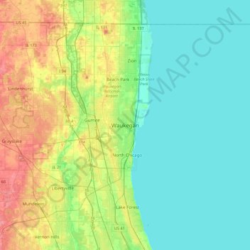
Nome: Mapa topográfico Waukegan, altitude, relevo.
Local: Waukegan, Lake County, Illinois, 60085, United States (42.20363 -88.00479 42.52363 -87.68479)
Altitude média: 200 m
Altitude mínima: 173 m
Altitude máxima: 270 m
Obrigado por apoiar este site ❤️
Faça uma doação
Faça uma doação