
Faça uma doação
Mapa topográfico Mount Sherman
Clique no mapa para exibir a altitude.
Faça uma doação
Sobre este mapa
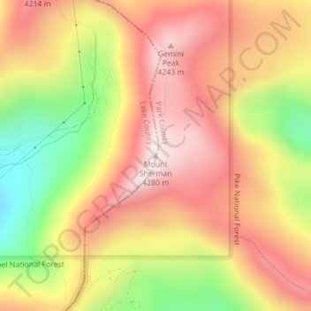
Nome: Mapa topográfico Mount Sherman, altitude, relevo.
Local: Mount Sherman, Lake County, Colorado, United States (39.22503 -106.17012 39.22513 -106.17002)
Altitude média: 3.989 m
Altitude mínima: 3.587 m
Altitude máxima: 4.278 m
Faça uma doação
Outros mapas topográficos
Clique em um mapa para visualizar sua topografia, sua altitude e seu relevo.
Leadville
United States > Colorado > Lake County
The City of Leadville is a statutory city that is the county seat, the most populous community, and the only incorporated municipality in Lake County, Colorado, United States. The city population was 2,602 at the 2010 census and an estimated 2,762 in 2018. It is situated at an elevation of 10,152 feet (3,094…
Altitude média: 3.107 m
Mount Massive Wilderness
United States > Colorado > Lake County
The Mount Massive Wilderness is a federally designated wilderness area in the Sawatch Range, located in the U.S. state of Colorado. It is operated jointly by the United States Forest Service and the Fish and Wildlife Service as part of the San Isabel National Forest and the Leadville National Fish Hatchery. It…
Altitude média: 3.432 m
Leadville
United States > Colorado > Lake County
The City of Leadville is a statutory city that is the county seat, the most populous community, and the only incorporated municipality in Lake County, Colorado, United States. The city population was 2,602 at the 2010 census and an estimated 2,762 in 2018. It is situated at an elevation of 10,152 feet (3,094…
Altitude média: 3.107 m
Faça uma doação