
Obrigado por apoiar este site ❤️
Faça uma doação
Faça uma doação
Mapa topográfico Kohima
Clique no mapa para exibir a altitude.
Obrigado por apoiar este site ❤️
Faça uma doação
Faça uma doação
Kohima
Kohima district is the land of the Angami Naga and Rengma Naga tribe. It is situated in the foothills of Japfu range located south of Kohima District (25°40′N 94°07′E / 25.67°N 94.12°E / 25.67; 94.12) and has an average elevation of 1,261 metres (4137 feet).
Obrigado por apoiar este site ❤️
Faça uma doação
Faça uma doação
Sobre este mapa
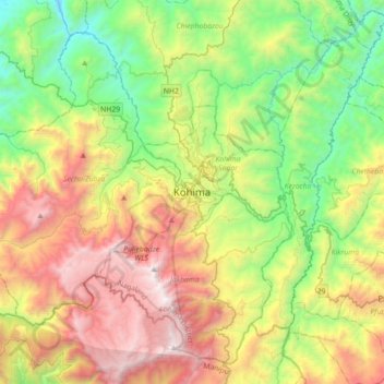
Nome: Mapa topográfico Kohima, altitude, relevo.
Local: Kohima, Kohima Sadar, Kohima District, Nagaland, 797001, India (25.50188 93.94192 25.82188 94.26192)
Altitude média: 1.425 m
Altitude mínima: 430 m
Altitude máxima: 2.993 m
Obrigado por apoiar este site ❤️
Faça uma doação
Faça uma doação