
Faça uma doação
Mapa topográfico Smithtown
Clique no mapa para exibir a altitude.
Faça uma doação
Sobre este mapa
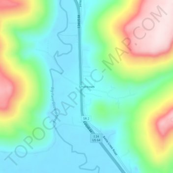
Nome: Mapa topográfico Smithtown, altitude, relevo.
Local: Smithtown, Marion County, Tennessee, United States (35.06119 -85.75497 35.10119 -85.71497)
Altitude média: 302 m
Altitude mínima: 182 m
Altitude máxima: 556 m
Faça uma doação
Outros mapas topográficos
Clique em um mapa para visualizar sua topografia, sua altitude e seu relevo.
South Pittsburg
United States > Tennessee > Marion County
South Pittsburg is located at 35°0′30″N 85°42′38″W / 35.00833°N 85.71056°W / 35.00833; -85.71056 (35.008342, -85.710645). The city is situated in the southwestern Sequatchie Valley between the Cumberland Plateau on the west and the Tennessee River (Guntersville Lake) on the east. Two steep…
Altitude média: 272 m
Raccoon Mountain Pumped Station Dam
United States > Tennessee > Marion County > Chattanooga
Altitude média: 415 m
Faça uma doação