
Faça uma doação
Mapa topográfico Ballay
Clique no mapa para exibir a altitude.
Faça uma doação
Sobre este mapa
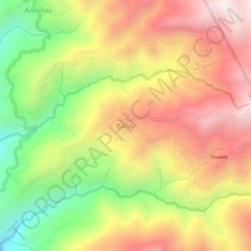
Nome: Mapa topográfico Ballay, altitude, relevo.
Altitude média: 1.829 m
Altitude mínima: 1.226 m
Altitude máxima: 2.361 m
Faça uma doação
Outros mapas topográficos
Clique em um mapa para visualizar sua topografia, sua altitude e seu relevo.
La Trinidad
The terrain is generally mountainous with springs, rivers and creeks. The town has a valley which encompasses several barangays. The valley floor elevation is at 1,300 metres (4,300 ft) above sea level. Elevation ranges from 500 to 1,700 metres (1,600 to 5,600 ft) above sea level.
Altitude média: 1.123 m
Faça uma doação
Faça uma doação
Faça uma doação
La Trinidad
The terrain is generally mountainous with springs, rivers and creeks. The town has a valley which encompasses several barangays. The valley floor elevation is at 1,300 metres (4,300 ft) above sea level. Elevation ranges from 500 to 1,700 metres (1,600 to 5,600 ft) above sea level.
Altitude média: 1.123 m
Faça uma doação
Ambuklao Dam
Philippines > Benguet > Ambuclao > Ambangol
SNAP-Benguet began a massive rehabilitation project that restored Ambuklao to operating status and increased its capacity from 75 MW to 105 MW. The project required the construction of a new intake, headrace and penstock, elevation of tailrace tunnel outlet, de-silting of tailrace tunnel and replacement of…
Altitude média: 808 m