
Faça uma doação
Mapa topográfico Achham
Clique no mapa para exibir a altitude.
Faça uma doação
Achham
Achham covers an area of 1,692 square kilometres (653 sq mi) and located at Latitude: 280°46’ North to 290°23' North and Longitude: 810°32 East to 810°35' East. 90% area of Achham is mid-hill and 10% is high-hill. The maximum elevation of the district is 3,820 metres (12,530 ft) and minimum elevation is 540 metres (1,770 ft) from the sea level. The district is surrounded by Bajura District in the North, Doti District in the West, Dailekh District in the East and Surkhet District in the South.
Faça uma doação
Sobre este mapa
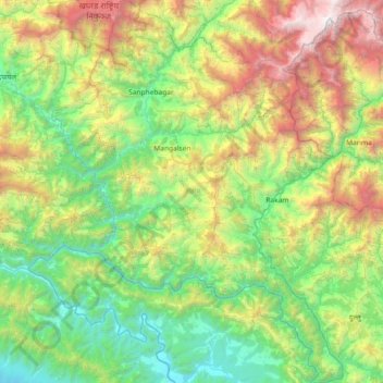
Nome: Mapa topográfico Achham, altitude, relevo.
Local: Achham, Sudurpashchim Province, 10709, Nepal (28.74829 81.02651 29.38639 81.58187)
Altitude média: 1.387 m
Altitude mínima: 207 m
Altitude máxima: 4.349 m
Faça uma doação
Outros mapas topográficos
Clique em um mapa para visualizar sua topografia, sua altitude e seu relevo.