
Faça uma doação
Mapa topográfico Mission
Clique no mapa para exibir a altitude.
Faça uma doação
Mission
The western part of the district, the Stave Valley, is largely rural and forested but its watercourse is home to what was the largest hydroelectric project in British Columbia until the Bridge River Power Project opened in 1961. It was built by the British Columbia Electric Railway (BCER) to provide power to the electric street railway and interurban system in Vancouver. The Stave Falls Power Co. operated a light-gauge railway for passenger and freight service up the lower canyon of the river to the dam at Stave Falls. During the construction of the Ruskin Dam (completed 1931) the railway was rebuilt at a higher elevation so as to skirt the new Hayward Lake reservoir. The rail line has long been discontinued, but the old grade and its trestles are now part of a recreation trail circling the reservoir.
Faça uma doação
Sobre este mapa
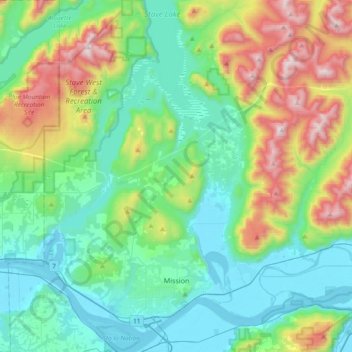
Nome: Mapa topográfico Mission, altitude, relevo.
Altitude média: 345 m
Altitude mínima: -1 m
Altitude máxima: 1.329 m
Faça uma doação
Outros mapas topográficos
Clique em um mapa para visualizar sua topografia, sua altitude e seu relevo.
Upper Sumas Pioneer Park
Canada > British Columbia > Fraser Valley Regional District > Abbotsford
Altitude média: 7 m
Abbotsford
Canada > British Columbia > Fraser Valley Regional District > Abbotsford
Altitude média: 115 m