
Mapa topográfico Kimpflen
Mapa interativo
Clique no mapa para exibir a altitude.
Sobre este mapa
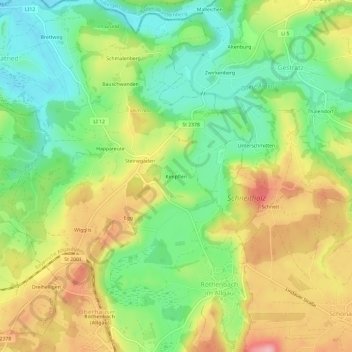
Nome: Mapa topográfico Kimpflen, altitude, relevo.
Altitude média: 666 m
Altitude mínima: 596 m
Altitude máxima: 757 m
Outros mapas topográficos
Clique em um mapa para visualizar sua topografia, sua altitude e seu relevo.
Rentershofen
Deutschland > Bayern > Landkreis Lindau > Röthenbach (Allgäu) > Oberhäuser
Rentershofen, Oberhäuser, Röthenbach (Allgäu), Argental (VGem), Landkreis Lindau, Bayern, 88167, Deutschland
Altitude média: 705 m