
Obrigado por apoiar este site ❤️
Faça uma doação
Faça uma doação
Mapa topográfico Upper Hardres
Clique no mapa para exibir a altitude.
Obrigado por apoiar este site ❤️
Faça uma doação
Faça uma doação
Sobre este mapa
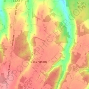
Nome: Mapa topográfico Upper Hardres, altitude, relevo.
Local: Upper Hardres, Canterbury, Kent, England, United Kingdom (51.18865 1.05821 51.22692 1.10129)
Altitude média: 120 m
Altitude mínima: 56 m
Altitude máxima: 154 m
Obrigado por apoiar este site ❤️
Faça uma doação
Faça uma doação
Outros mapas topográficos
Clique em um mapa para visualizar sua topografia, sua altitude e seu relevo.
Obrigado por apoiar este site ❤️
Faça uma doação
Faça uma doação
Obrigado por apoiar este site ❤️
Faça uma doação
Faça uma doação
Obrigado por apoiar este site ❤️
Faça uma doação
Faça uma doação
Obrigado por apoiar este site ❤️
Faça uma doação
Faça uma doação
Shalmsford Street
United Kingdom > England > Kent > Canterbury > Shalmsford Street
Altitude média: 54 m
Obrigado por apoiar este site ❤️
Faça uma doação
Faça uma doação
Obrigado por apoiar este site ❤️
Faça uma doação
Faça uma doação
Obrigado por apoiar este site ❤️
Faça uma doação
Faça uma doação