
Obrigado por apoiar este site ❤️
Faça uma doação
Faça uma doação
Mapa topográfico Barton
Clique no mapa para exibir a altitude.
Obrigado por apoiar este site ❤️
Faça uma doação
Faça uma doação
Sobre este mapa
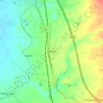
Nome: Mapa topográfico Barton, altitude, relevo.
Local: Barton, Preston, Lancashire, England, PR3 5AS, United Kingdom (53.81180 -2.75612 53.85180 -2.71612)
Altitude média: 32 m
Altitude mínima: 11 m
Altitude máxima: 69 m
Obrigado por apoiar este site ❤️
Faça uma doação
Faça uma doação
Outros mapas topográficos
Clique em um mapa para visualizar sua topografia, sua altitude e seu relevo.