
Mapa topográfico Pangong Tso
Mapa interativo
Clique no mapa para exibir a altitude.
Sobre este mapa
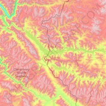
Nome: Mapa topográfico Pangong Tso, altitude, relevo.
Local: Pangong Tso, Rutog County, Ngari Prefecture, Tibet, China (33.42971 78.41971 33.98425 79.93191)
Altitude média: 5.119 m
Altitude mínima: 3.493 m
Altitude máxima: 6.599 m
Pangong Tso or Pangong Lake (Tibetan: སྤང་གོང་མཚོ; Chinese: 班公错, Pinyin: Bān gōng cuò, Hindi: पैंगोंग झील) is an endorheic lake in the Himalayas situated at an elevation of 4,225 m (13,862 ft). It is 134 km (83 mi) long and extends from Ladakh, India to the Tibetan Autonomous Region, China. Approximately 60% of the length of the lake lies within the Tibetan Autonomous Region. The lake is 5 km (3.1 mi) wide at its broadest point. All together it covers 604 km2. During winter the lake freezes completely, despite being saline water. It is not a part of the Indus River basin area and geographically a separate landlocked river basin.
Outros mapas topográficos
Clique em um mapa para visualizar sua topografia, sua altitude e seu relevo.
Kunlun Mountains
China > Tibet > Rutog County > Dongru
Kunlun Mountains, Dongru, Rutog County, Ngari Prefecture, Tibet, China
Altitude média: 6.188 m