
Mapa topográfico Bebington
Clique no mapa para exibir a altitude.
Bebington
Bebington is on the eastern side of the Wirral Peninsula, approximately 10 km (6.2 mi) south-south-east of the Irish Sea at New Brighton, about 7.5 km (4.7 mi) east-north-east of the Dee Estuary at Gayton and less than 2 km (1.2 mi) west-north-west of the River Mersey at New Ferry. The area is situated at an elevation of between 20–60 m (66–197 ft) above sea level.
Sobre este mapa
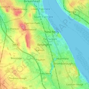
Nome: Mapa topográfico Bebington, altitude, relevo.
Altitude média: 28 m
Altitude mínima: 0 m
Altitude máxima: 84 m
Outros mapas topográficos
Clique em um mapa para visualizar sua topografia, sua altitude e seu relevo.
Sheffield
Sheffield nestles on the eastern foothills of the Pennines and is sculpted by a dramatic hill-and-valley system formed where five rivers — the Don, Sheaf, Rivelin, Loxley and Porter — converge, producing steep-sided valleys and gritstone ridgelines with much of the urban area built directly onto hillsides…
Altitude média: 168 m
Kent
Kent was also the location of the largest number of art schools in the country during the nineteenth century, estimated by the art historian David Haste, to approach two hundred. This is believed to be the result of Kent being a front line county during the Napoleonic Wars. At this time, before the invention…
Altitude média: 37 m
Birmingham
Birmingham is a snowy city relative to other large UK conurbations, due to its inland location and comparatively high elevation. Between 1961 and 1990 Birmingham Airport averaged 13.0 days of snow lying annually, compared to 5.33 at London Heathrow. Snow showers often pass through the city via the Cheshire gap…
Altitude média: 138 m
East of England
The East of England region has the lowest elevation range in the UK. Twenty percent of the region is below mean sea level, most of this in North Cambridgeshire, Norfolk and on the Essex Coast. Most of the remaining area is of low elevation, with extensive glacial deposits. The Fens, a large area of reclaimed…
Altitude média: 39 m
Lake District National Park
The Lake District is a roughly circular upland massif, deeply dissected by a broadly radial pattern of major valleys which are largely the result of repeated glaciations over the last 2 million years. The apparent radial pattern is not from a central dome, but from an axial watershed extending from St Bees…
Altitude média: 206 m
Suffolk
The west of the county lies on more resistant Cretaceous chalk. This chalk is responsible for a sweeping tract of largely downland landscapes that stretches from Dorset in the south west to Dover in the south east and north through East Anglia to the Yorkshire Wolds. The chalk is less easily eroded so forms…
Altitude média: 35 m
Ipswich
United Kingdom > England > Suffolk
Ipswich experiences an oceanic climate, like the rest of the British Isles, with a narrow range of temperature and rainfall spread evenly throughout the year. One of the two nearest for which data is available is East Bergholt, about 7 miles (11 km) south west of the town centre and at a similar elevation, and…
Altitude média: 29 m
Cambridge
United Kingdom > England > Cambridge
The city, like most of the UK, has a maritime climate highly influenced by the Gulf Stream. Located in the driest region of Britain, Cambridge's rainfall averages around 570 mm (22.44 in) per year, around half the national average, with some years occasionally falling into the semi-arid (under 500 mm (19.69…
Altitude média: 18 m
Hertfordshire
Elevations are higher in the north and west, reaching more than 800 feet (240 m) in the Chilterns near Tring. The county centres on the headwaters and upper valleys of the rivers Lea and the Colne; both flow south, and each is accompanied by a canal. Hertfordshire's undeveloped land is mainly agricultural,…
Altitude média: 82 m
Yorkshire
In Yorkshire there is a very close relationship between the major topographical areas and the geological period in which they were formed. The Pennine chain of hills in the west is of Carboniferous origin. The central vale is Permo-Triassic. The North York Moors in the north-east of the county are Jurassic in…
Altitude média: 130 m
Cambridgeshire
Cambridgeshire has a maritime temperate climate which is broadly similar to the rest of the United Kingdom, though it is drier than the UK average due to its low altitude and easterly location, the prevailing southwesterly winds having already deposited moisture on higher ground further west. Average winter…
Altitude média: 32 m
Surrey
United Kingdom > England > Surrey
The highest elevation in Surrey is Leith Hill near Dorking. It is 295 m (968 ft) above sea level and is the second highest point in southeastern England after Walbury Hill in West Berkshire which is 297 m (974 ft).
Altitude média: 69 m
North East England
North East England has a Marine west coast climate (generally found along the west coast of middle latitude continents) with narrower temperature ranges than the south of England and sufficient precipitation in all months. Summers and winters are mild rather than extremely hot or cold, due to the strong…
Altitude média: 165 m
South East England
Near Weybridge are the UK headquarters of Sony with SSP Group (situated in Byfleet) and Procter & Gamble (next door to each other on The Heights Business Park near the former Brooklands racing circuit) with Kia Motors UK and Petroleum Geo-Services UK, and Gallaher Group (cigarettes) is to the north, next to…
Altitude média: 69 m
Isle of Portland
United Kingdom > England > Dorset > Wyke Regis
In Museums Without Walls, Jonathan Meades declares that "Portland is a bulky chunk of geological, social, topographical and demographic weirdness. It is the obverse of a beauty spot. 'Beauty' in this construction implies the picturesque. Portland is gloriously bereft of this quality. It is awesome. There is…
Altitude média: 11 m
Bath
United Kingdom > England > Bath and North East Somerset
Bath is in the Avon Valley and is surrounded by limestone hills as it is near the southern edge of the Cotswolds, a designated Area of Outstanding Natural Beauty, and the limestone Mendip Hills rise around 7 miles (11 km) south of the city. The hills that surround and make up the city have a maximum altitude…
Altitude média: 100 m
Dartmoor National Park
United Kingdom > England > Devon
Rainfall tends to be associated with Atlantic depressions or with convection. In summer, convection caused by solar surface heating sometimes forms shower clouds and a large proportion of rainfall falls from showers and thunderstorms at this time of year. The wettest months are November and December and on the…
Altitude média: 239 m
Exeter
United Kingdom > England > Devon
The city of Exeter was established on the eastern bank of the River Exe on a ridge of land backed by a steep hill. It is at this point that the Exe, having just been joined by the River Creedy, opens onto a wide flood plain and estuary which results in quite common flooding. Historically this was the lowest…
Altitude média: 56 m
Shobnall
United Kingdom > England > Staffordshire > East Staffordshire > Burton-on-Trent
Altitude média: 56 m
Stratton Brook
United Kingdom > England > Surrey > Tandridge > Godstone > Church Town
Altitude média: 117 m
Market Weighton
United Kingdom > England > East Riding of Yorkshire > Market Weighton
Altitude média: 43 m
Reading
Jane Austen attended Reading Ladies Boarding School, based in the Abbey Gateway, in 1784–1786. Mary Russell Mitford lived in Reading for a number of years and then spent the rest of her life just outside the town at Three Mile Cross and Swallowfield. The fictional Belford Regis of her eponymous novel, first…
Altitude média: 54 m
Greater London
London's topography is characterized by a gently rolling terrain shaped by the River Thames and its tributaries. The city lies within the London Basin, a natural depression bordered by higher grounds such as the North Downs to the south and the Chiltern Hills to the northwest. The Thames flows west to east,…
Altitude média: 66 m
Crawley
United Kingdom > England > West Sussex
Crawley lies within the Sussex Weald, an area of highly variable terrain so that many microclimates of frost hollows, sun traps and windswept hilltops will be encountered over a short distance. During calm, clear periods of weather this allows for some interesting temperature variations, although most of the…
Altitude média: 80 m