
Faça uma doação
Mapa topográfico Blue Ridge
Clique no mapa para exibir a altitude.
Faça uma doação
Blue Ridge
Blue Ridge, situated in Fannin County, Georgia, lies within the rugged terrain of the southern Appalachian Mountains. The town itself is at an elevation of approximately 1,762 feet (537 meters) above sea level. The surrounding landscape is characterized by a series of ridges and valleys, with elevations ranging from about 1,549 feet (472 meters) to over 2,000 feet (610 meters). This varied topography contributes to the area's rich biodiversity and offers numerous opportunities for outdoor recreation, including hiking, mountain biking, and wildlife observation.
Faça uma doação
Sobre este mapa
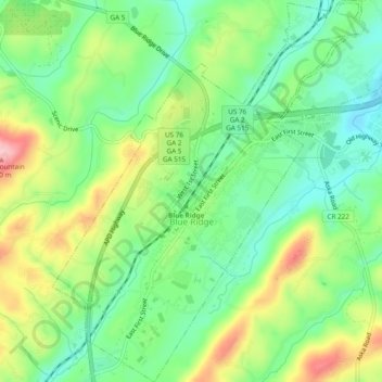
Nome: Mapa topográfico Blue Ridge, altitude, relevo.
Local: Blue Ridge, Fannin County, Georgia, United States (34.84741 -84.34159 34.88675 -84.29448)
Altitude média: 535 m
Altitude mínima: 472 m
Altitude máxima: 639 m
Faça uma doação
Outros mapas topográficos
Clique em um mapa para visualizar sua topografia, sua altitude e seu relevo.
Faça uma doação
Springer Mountain
United States > Georgia > Fannin County
Springer Mountain is a mountain located in the Chattahoochee National Forest on the border of Fannin and Gilmer counties. Located in the Blue Ridge Mountains in northern Georgia, the mountain has an elevation of about 3,782 feet (1,153 m). Springer Mountain serves as the southern terminus for the Appalachian…
Altitude média: 941 m
Faça uma doação
Faça uma doação
Faça uma doação
Springer Mountain
United States > Georgia > Fannin County
Springer Mountain is a mountain located in the Chattahoochee National Forest on the border of Fannin and Gilmer counties. Located in the Blue Ridge Mountains in northern Georgia, the mountain has an elevation of about 3,782 feet (1,153 m). Springer Mountain serves as the southern terminus for the Appalachian…
Altitude média: 941 m