
Faça uma doação
Mapa topográfico Alderminster CP
Clique no mapa para exibir a altitude.
Faça uma doação
Sobre este mapa
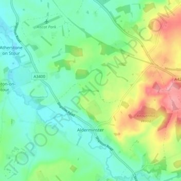
Nome: Mapa topográfico Alderminster CP, altitude, relevo.
Altitude média: 70 m
Altitude mínima: 36 m
Altitude máxima: 141 m
Faça uma doação
Outros mapas topográficos
Clique em um mapa para visualizar sua topografia, sua altitude e seu relevo.
Faça uma doação
Big Clowes Wood
United Kingdom > England > Warwickshire > Stratford-on-Avon > Tanworth in Arden CP
Altitude média: 152 m
Burton Dassett Hills Country Park
United Kingdom > England > Warwickshire > Stratford-on-Avon > Northend > Burton Dassett CP
Altitude média: 132 m
Cranhill
United Kingdom > England > Warwickshire > Stratford-on-Avon > Ardens Grafton
Altitude média: 57 m
Faça uma doação
Oversley Wood
United Kingdom > England > Warwickshire > Stratford-on-Avon > Alcester > Exhall
Altitude média: 64 m
Faça uma doação
Faça uma doação
Sutton-under-Brailes
United Kingdom > England > Warwickshire > Stratford-on-Avon > Stourton
Altitude média: 125 m
Faça uma doação
Walton
United Kingdom > England > Warwickshire > Stratford-on-Avon > Wellesbourne
Altitude média: 76 m
Faça uma doação
Arlescote
United Kingdom > England > Warwickshire > Stratford-on-Avon > Warmington CP
Altitude média: 148 m
Faça uma doação
Bishopton
United Kingdom > England > Warwickshire > Stratford-on-Avon > Stratford-upon-Avon
Altitude média: 64 m
Marlcliff
United Kingdom > England > Warwickshire > Stratford-on-Avon > Bidford on Avon CP
Altitude média: 41 m
River Avon
United Kingdom > England > Warwickshire > Stratford-on-Avon > Stratford-upon-Avon > Clifford Chambers
Altitude média: 43 m
Faça uma doação
Pillerton Hersey
United Kingdom > England > Warwickshire > Stratford-on-Avon > Pillerton Hersey
Altitude média: 92 m
Faça uma doação
Pathlow
United Kingdom > England > Warwickshire > Stratford-on-Avon > Wilmcote CP
Altitude média: 84 m
Faça uma doação
Lower Binton
United Kingdom > England > Warwickshire > Stratford-on-Avon > Binton
Altitude média: 52 m
Ladbroke (Millennium Green)
United Kingdom > England > Warwickshire > Stratford-on-Avon > Ladbroke CP
Altitude média: 98 m
Winderton
United Kingdom > England > Warwickshire > Stratford-on-Avon > Winderton
Altitude média: 151 m
Faça uma doação
Upper Quinton
United Kingdom > England > Warwickshire > Stratford-on-Avon > Lower Quinton > Upper Quinton
Altitude média: 70 m
Lye Green
United Kingdom > England > Warwickshire > Stratford-on-Avon > Claverdon > Lye Green
Altitude média: 106 m
Faça uma doação
Faça uma doação
Edstone
United Kingdom > England > Warwickshire > Stratford-on-Avon > Wootton Wawen CP
Altitude média: 90 m
Faça uma doação