Mapa topográfico Nelson Ledges Quarry Park
Mapa interativo
Clique no mapa para exibir a altitude.
Sobre este mapa
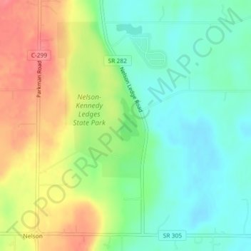
Nome: Mapa topográfico Nelson Ledges Quarry Park, altitude, relevo.
Altitude média: 306 m
Altitude mínima: 276 m
Altitude máxima: 351 m

Clique no mapa para exibir a altitude.
Nome: Mapa topográfico Nelson Ledges Quarry Park, altitude, relevo.
Altitude média: 306 m
Altitude mínima: 276 m
Altitude máxima: 351 m