
Faça uma doação
Mapa topográfico Carshalton
Clique no mapa para exibir a altitude.
Faça uma doação
Sobre este mapa
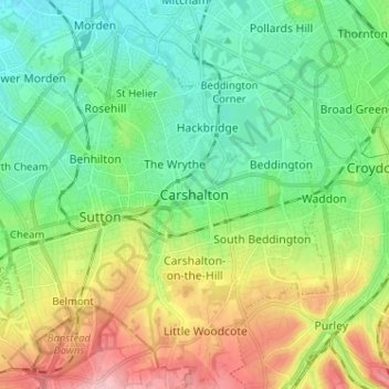
Nome: Mapa topográfico Carshalton, altitude, relevo.
Local: Carshalton, Greater London, England, SM5 3AT, United Kingdom (51.32579 -0.20109 51.40579 -0.12109)
Altitude média: 62 m
Altitude mínima: 13 m
Altitude máxima: 159 m
Faça uma doação
Outros mapas topográficos
Clique em um mapa para visualizar sua topografia, sua altitude e seu relevo.
Faça uma doação
Norwood Grove
United Kingdom > England > Greater London
After Anderson died, ownership passed to the Nettlefold family and subsequently to Frederick Nettlefold the brother of Joseph Nettlefold and a member of the family that founded the Nettlefolds Ltd. engineering firm which later became GKN. Nettlefold is commemorated, as a result of his charitable works, by a…
Altitude média: 58 m
Faça uma doação
Faça uma doação
Faça uma doação
Faça uma doação
Faça uma doação
Pymmes Brook
United Kingdom > England > Greater London
Prior to the Anglian glaciation, a "proto-Mole-Wey" river was flowing northwards from the Weald and North Downs, through the "Finchley depression" and Palmers Green, to join the proto-Thames somewhere around Hoddesdon, at what is today an altitude of around 60 metres. It was this river which, during the course…
Altitude média: 41 m
Faça uma doação
Faça uma doação
Faça uma doação
Faça uma doação
Faça uma doação